Skip to content

Home

About Us

Contact Us

  • Facebook
  • X
  • Instagram
  • Pinterest
  • WhatsApp
  • RSS Feed
  • TikTok

Seven Lakes News

Your Trusted Voice Across the World.

Search

Storm Coverage Expands Across Ohio This Afternoon and Evening as Model Guidance Hints at Low End Damaging Wind Potential in Isolated Pockets

Justin Lyle Avatar
Justin Lyle
August 12, 2026
Storm Coverage Expands Across Ohio This Afternoon and Evening as Model Guidance Hints at Low End Damaging Wind Potential in Isolated Pockets

OHIO — Latest short-range model guidance shows expanding storm coverage pushing east across Ohio through the afternoon and evening Wednesday. Most spots will just see downpours and gusty winds, though the newest model runs are hinting at low end damaging wind potential in a few pockets, making this a stay-aware kind of setup rather than a major severe weather concern.

Storm Coverage Expected to Push East Through Afternoon Hours

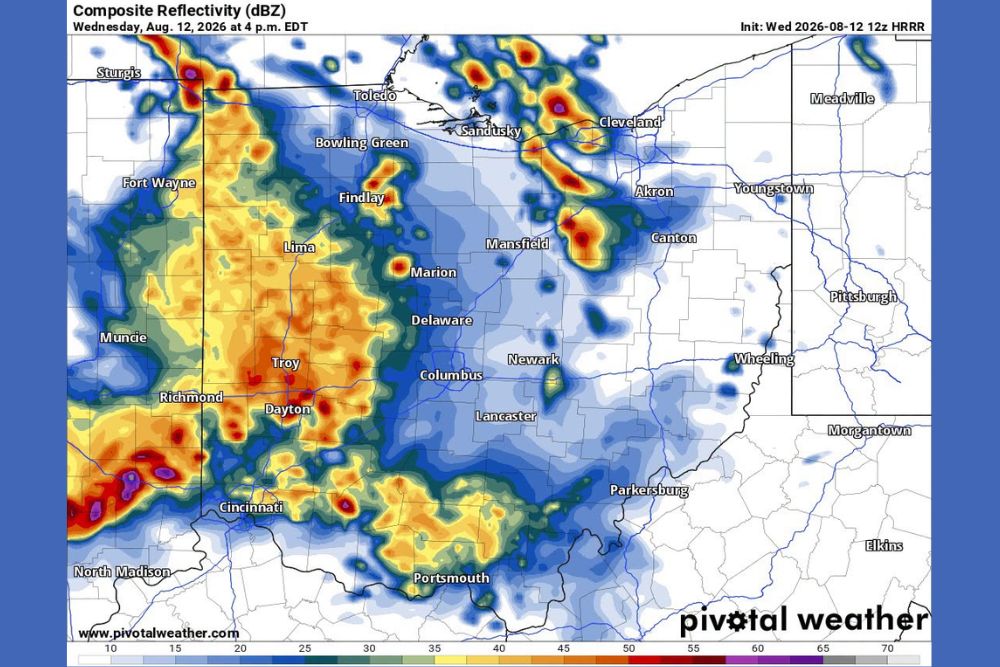
Simulated radar valid for 4 p.m. Wednesday shows a broad area of storm coverage stretching across a corridor from Cincinnati and Dayton through Columbus, Marion, and toward Cleveland. The heaviest activity, shown in orange and red returns, is concentrated over the Cincinnati, Dayton, and Columbus corridor.

This initial round of coverage reflects the leading edge of the system as it begins moving through southwestern and central Ohio during the early to mid afternoon hours.

Coverage Continues Expanding Toward Evening Hours

By 6 p.m., simulated radar shows the storm coverage continuing to expand and shift east, with intensifying activity near Cleveland, Akron, and Canton. The Cincinnati and Columbus areas continue showing pockets of heavier returns as the system progresses through the evening.

This eastward expansion suggests communities across the northeastern part of the state, including Youngstown and Canton, should prepare for storm chances arriving later in the evening compared to areas farther west and south.

Most Areas Expected to See Downpours and Gusty Winds

For the majority of communities within the forecast area, the primary impacts are expected to be downpours and gusty winds rather than more significant severe weather. This includes areas such as Lima, Marion, and Newark, which fall within the broader coverage area without being highlighted for elevated concern.

Forecasters emphasized that nothing major is expected with this setup, characterizing it as a typical afternoon and evening storm chance rather than an organized severe weather event.

Isolated Pockets Could See Low End Damaging Wind Gusts

Despite the generally modest expectations, the newest model runs are hinting at low end damaging wind potential developing in a few isolated pockets across the forecast area. These pockets could see stronger gusts compared to the broader downpour and gusty wind theme affecting most locations.

Residents across Ohio, including those in Columbus, Dayton, and Cleveland, are encouraged to stay weather aware through the afternoon and evening as storm coverage continues expanding and evolving through the day.
Leave a Reply Cancel reply

Your email address will not be published. Required fields are marked *

Featured Articles

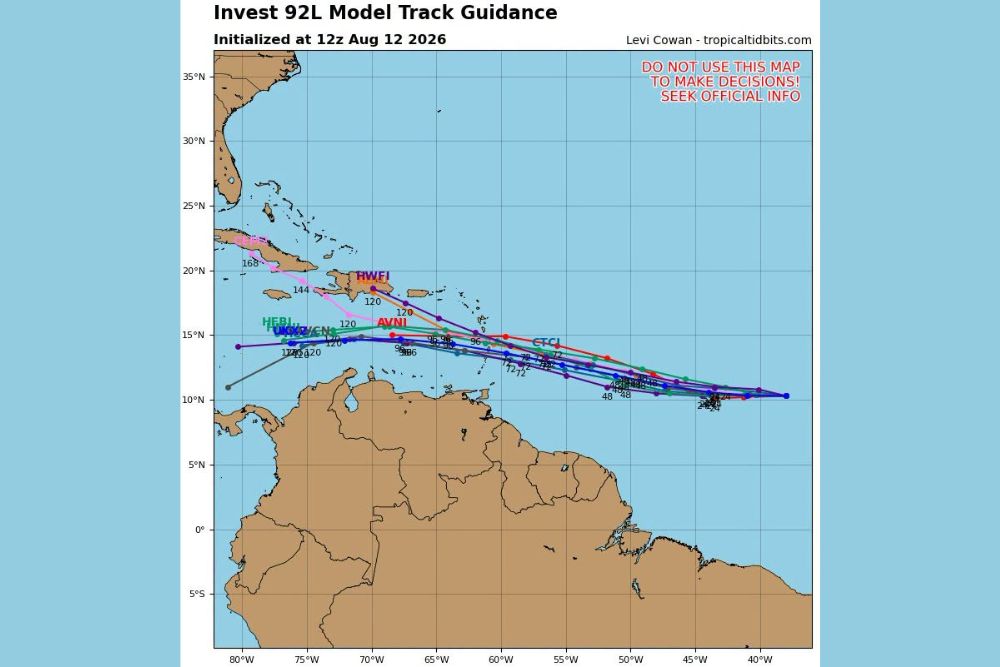
  • Invest 92L Spaghetti Models Show General Westward Track Through Caribbean With Strong Wind Shear Threatening System While Trailing Wave Looks Healthy

    Invest 92L Spaghetti Models Show General Westward Track Through Caribbean With Strong Wind Shear Threatening System While Trailing Wave Looks Healthy

    August 12, 2026
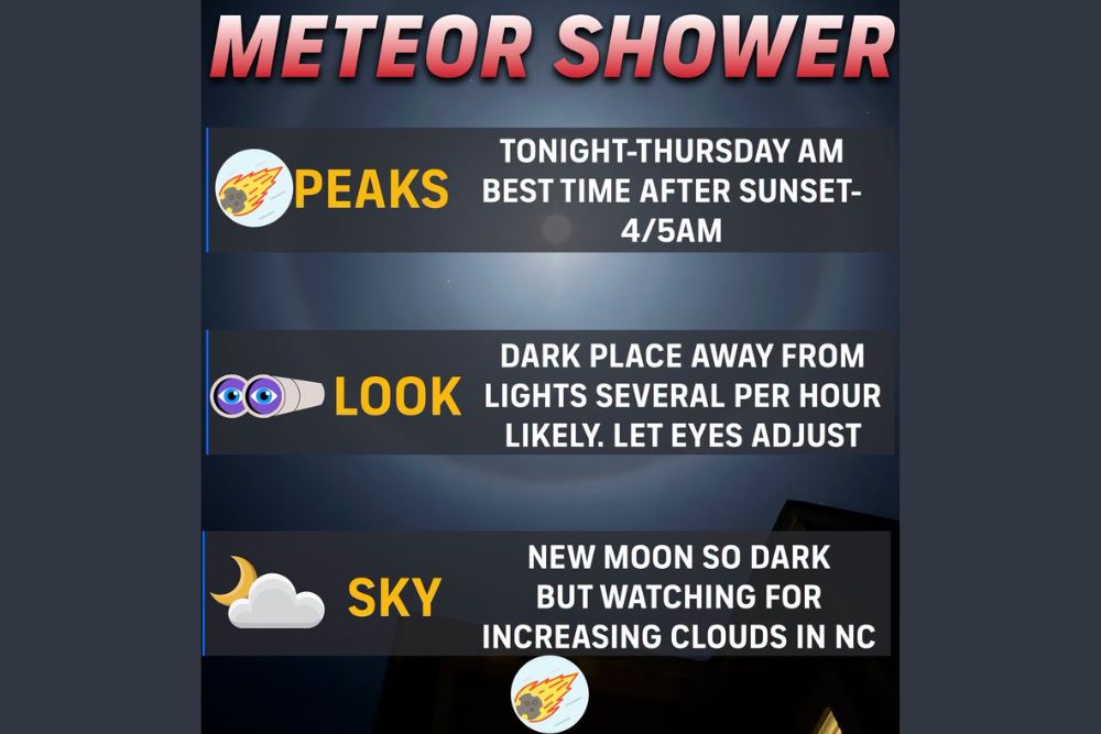
  • Perseid Meteor Shower Peaks Tonight Across North Carolina With New Moon Skies but Passing Clouds Threatening Viewing Conditions Statewide

    Perseid Meteor Shower Peaks Tonight Across North Carolina With New Moon Skies but Passing Clouds Threatening Viewing Conditions Statewide

    August 12, 2026
  • Severe Storm Complex Barrels Across Northern Illinois Toward South Bend With Damaging Winds Up to Seventy-Five MPH and Spin Up Tornado Risk

    Severe Storm Complex Barrels Across Northern Illinois Toward South Bend With Damaging Winds Up to Seventy-Five MPH and Spin Up Tornado Risk

    August 12, 2026
  • HiRes Model Points to Four Inch Plus Rain Totals Over Northeast Nebraska Wednesday Night With Isolated Amounts Reaching Up to Seven and a Half Inches

    HiRes Model Points to Four Inch Plus Rain Totals Over Northeast Nebraska Wednesday Night With Isolated Amounts Reaching Up to Seven and a Half Inches

    August 12, 2026
  • Another Bow Echo Sends Strong Thunderstorm Winds Through Chicago Suburbs With Gusts to Seventy-Five MPH Reported Near Midway Airport

    Another Bow Echo Sends Strong Thunderstorm Winds Through Chicago Suburbs With Gusts to Seventy-Five MPH Reported Near Midway Airport

    August 12, 2026

Search

Follow Us on

  • Facebook
  • X
  • Instagram
  • VK
  • Pinterest
  • Last.fm
  • TikTok
  • Telegram
  • WhatsApp
  • RSS Feed

Categories

  • Climate Forecast (16)

About Seven Lakes News

We cover the weather that changes your day: storm warnings, heat and cold advisories, flooding, snow, and the forecasts behind them. We are not the National Weather Service and we do not issue warnings. When severe weather is close, check weather.gov or your local NWS office before you act on anything you read here.

Latest Articles

  • Invest 92L Spaghetti Models Show General Westward Track Through Caribbean With Strong Wind Shear Threatening System While Trailing Wave Looks Healthy

    Invest 92L Spaghetti Models Show General Westward Track Through Caribbean With Strong Wind Shear Threatening System While Trailing Wave Looks Healthy

    August 12, 2026
  • Perseid Meteor Shower Peaks Tonight Across North Carolina With New Moon Skies but Passing Clouds Threatening Viewing Conditions Statewide

    Perseid Meteor Shower Peaks Tonight Across North Carolina With New Moon Skies but Passing Clouds Threatening Viewing Conditions Statewide

    August 12, 2026
  • Severe Storm Complex Barrels Across Northern Illinois Toward South Bend With Damaging Winds Up to Seventy-Five MPH and Spin Up Tornado Risk

    Severe Storm Complex Barrels Across Northern Illinois Toward South Bend With Damaging Winds Up to Seventy-Five MPH and Spin Up Tornado Risk

    August 12, 2026

Categories

  • Climate Forecast (16)
August 2026
M T W T F S S
 12
3456789
10111213141516
17181920212223
24252627282930
31  
     

© 2026 Seven Lakes News | All Rights Reserved.

Scroll to Top