
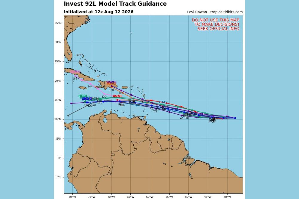
ATLANTIC — The latest Wednesday spaghetti model guidance for Invest 92 shows a general westward track expected as the system approaches the Caribbean. Model tracks initialized at 12z Wednesday depict a wide range of possible paths, with significant wind shear positioned in the Caribbean that several models suggest could cause the system to fizzle before making further progress west.
Model Guidance Shows Westward Track Toward Caribbean Islands
The ensemble of model tracks initialized Wednesday shows Invest 92L generally tracking west from its current position east of the Lesser Antilles, with individual model runs clustering in a band stretching from roughly 15 to 20 degrees north latitude as the system approaches the eastern Caribbean.
Some individual models, including runs showing intensity values reaching into the 120s, suggest the potential for a more organized system, while others depict a weaker track with intensity values remaining considerably lower as the system moves west.
Strong Wind Shear in Caribbean Poses Challenge for Development
A significant amount of wind shear is positioned in the Caribbean for the system to try and pass through, and some model guidance suggests this hostile environment could cause the system to fizzle rather than continue strengthening as it tracks westward.
This shear-related uncertainty is reflected in the spread among model tracks, with some guidance showing a system that maintains organization through the Caribbean while other runs suggest weakening or dissipation before reaching the western Caribbean or beyond.
Trailing Tropical Wave Not Yet an Invest but Appears Healthy
Behind Invest 92, a separate tropical wave has not yet been designated as an official invest but is described as looking healthy based on current satellite presentation. This wave will require continued monitoring to determine whether it eventually earns a formal designation.
Should this trailing wave continue showing signs of organization, it would become the next system for forecasters to track as it follows a similar path across the tropical Atlantic toward the Caribbean region.
Spaghetti Model Guidance Comes With Standard Forecast Caveats
The tropicaltidbits.com spaghetti model graphic includes a clear caution not to use the map to make decisions, instead directing residents to seek official information from the National Hurricane Center. This reflects the inherent uncertainty present in early-stage, multi-model guidance for a system still several days from any potential Caribbean impact.
Residents across the Caribbean and southeastern United States are encouraged to continue monitoring official National Hurricane Center updates as Invest 92L and the trailing tropical wave continue to develop over the coming days.
Leave a Reply