Skip to content

Home

About Us

Contact Us

  • Facebook
  • X
  • Instagram
  • Pinterest
  • WhatsApp
  • RSS Feed
  • TikTok

Seven Lakes News

Your Trusted Voice Across the World.

Search

NHC Designates AL92 and AL93 With Eighty Percent Development Odds Each as Tropical System Nears African Coast and Northern Atlantic

Justin Lyle Avatar
Justin Lyle
August 12, 2026
NHC Designates AL92 and AL93 With Eighty Percent Development Odds Each as Tropical System Nears African Coast and Northern Atlantic

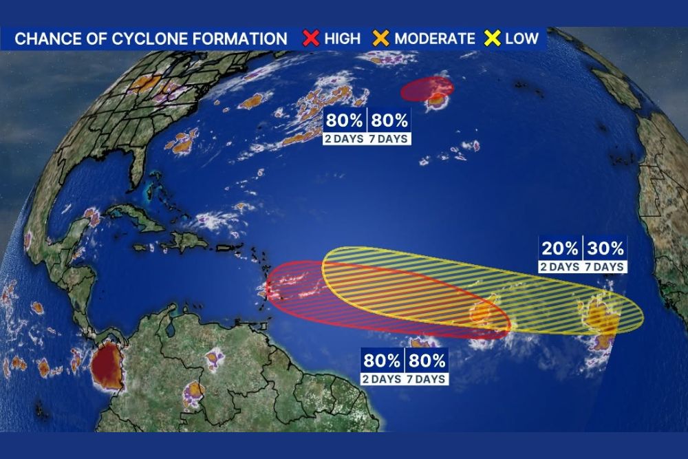
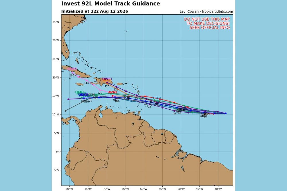
ATLANTIC — The National Hurricane Center’s 10 a.m. update now has two systems designated in the Atlantic basin, AL92 and AL93, each carrying up to an 80 percent chance of development. AL93, positioned in the northern Atlantic, is likely to become a short-lived tropical system moving east, while AL92, located off the African coastline, should become a tropical depression as it moves west.

AL93 Likely to Become Short-Lived System Moving East

AL93, shown as a red blob in the northern Atlantic on the latest tropical outlook, now carries an 80 percent chance of development over both the 2-day and 7-day windows. This system is likely to become a short-lived tropical system as it continues tracking eastward across the open Atlantic.

The northern positioning of AL93 means any resulting system would likely remain well away from land areas, consistent with its expected short-lived nature as it moves through the open ocean environment.

AL92 Should Become Tropical Depression Moving West Off Africa

AL92, positioned as a red blob just off the African coastline, also now carries an 80 percent chance of development across both time windows. This system should become a tropical depression as it continues moving west away from the African continent.

Given its position closest to the African coast among the currently tracked systems, AL92 will require the longest track across the Atlantic before any potential threat to more distant areas would need to be assessed.

Tropical Wave Closest to Africa Carries Thirty Percent Chance

A separate tropical wave, identified as the system currently closest to Africa, carries up to a 30 percent chance of development over the next 7 days, with a lower 20 percent chance in the shorter 2-day window. This wave sits within a broader monitoring area stretching across the central tropical Atlantic.

This system represents an earlier-stage disturbance compared to AL92 and AL93, reflecting the typical progression of tropical waves as they emerge off Africa and gradually organize while crossing the basin.

Multiple Systems Reflect Active Stretch in Atlantic Basin

With three separate areas now being tracked by the National Hurricane Center, the Atlantic basin is showing signs of an increasingly active stretch as the season progresses. Forecasters will continue monitoring all three systems as they evolve over the coming days.

Residents and those with interests along the Atlantic and Gulf coasts are encouraged to stay updated as the National Hurricane Center continues providing regular tropical outlook updates on AL92, AL93, and the additional tracked tropical wave.
Leave a Reply Cancel reply

Your email address will not be published. Required fields are marked *

Featured Articles

  • Invest 92L Spaghetti Models Show General Westward Track Through Caribbean With Strong Wind Shear Threatening System While Trailing Wave Looks Healthy

    Invest 92L Spaghetti Models Show General Westward Track Through Caribbean With Strong Wind Shear Threatening System While Trailing Wave Looks Healthy

    August 12, 2026
  • Perseid Meteor Shower Peaks Tonight Across North Carolina With New Moon Skies but Passing Clouds Threatening Viewing Conditions Statewide

    Perseid Meteor Shower Peaks Tonight Across North Carolina With New Moon Skies but Passing Clouds Threatening Viewing Conditions Statewide

    August 12, 2026
  • Severe Storm Complex Barrels Across Northern Illinois Toward South Bend With Damaging Winds Up to Seventy-Five MPH and Spin Up Tornado Risk

    Severe Storm Complex Barrels Across Northern Illinois Toward South Bend With Damaging Winds Up to Seventy-Five MPH and Spin Up Tornado Risk

    August 12, 2026
  • HiRes Model Points to Four Inch Plus Rain Totals Over Northeast Nebraska Wednesday Night With Isolated Amounts Reaching Up to Seven and a Half Inches

    HiRes Model Points to Four Inch Plus Rain Totals Over Northeast Nebraska Wednesday Night With Isolated Amounts Reaching Up to Seven and a Half Inches

    August 12, 2026
  • Another Bow Echo Sends Strong Thunderstorm Winds Through Chicago Suburbs With Gusts to Seventy-Five MPH Reported Near Midway Airport

    Another Bow Echo Sends Strong Thunderstorm Winds Through Chicago Suburbs With Gusts to Seventy-Five MPH Reported Near Midway Airport

    August 12, 2026

Search

Follow Us on

  • Facebook
  • X
  • Instagram
  • VK
  • Pinterest
  • Last.fm
  • TikTok
  • Telegram
  • WhatsApp
  • RSS Feed

Categories

  • Climate Forecast (16)

About Seven Lakes News

We cover the weather that changes your day: storm warnings, heat and cold advisories, flooding, snow, and the forecasts behind them. We are not the National Weather Service and we do not issue warnings. When severe weather is close, check weather.gov or your local NWS office before you act on anything you read here.

Latest Articles

  • Invest 92L Spaghetti Models Show General Westward Track Through Caribbean With Strong Wind Shear Threatening System While Trailing Wave Looks Healthy

    Invest 92L Spaghetti Models Show General Westward Track Through Caribbean With Strong Wind Shear Threatening System While Trailing Wave Looks Healthy

    August 12, 2026
  • Perseid Meteor Shower Peaks Tonight Across North Carolina With New Moon Skies but Passing Clouds Threatening Viewing Conditions Statewide

    Perseid Meteor Shower Peaks Tonight Across North Carolina With New Moon Skies but Passing Clouds Threatening Viewing Conditions Statewide

    August 12, 2026
  • Severe Storm Complex Barrels Across Northern Illinois Toward South Bend With Damaging Winds Up to Seventy-Five MPH and Spin Up Tornado Risk

    Severe Storm Complex Barrels Across Northern Illinois Toward South Bend With Damaging Winds Up to Seventy-Five MPH and Spin Up Tornado Risk

    August 12, 2026

Categories

  • Climate Forecast (16)
August 2026
M T W T F S S
 12
3456789
10111213141516
17181920212223
24252627282930
31  
     

© 2026 Seven Lakes News | All Rights Reserved.

Scroll to Top