Skip to content

Home

About Us

Contact Us

  • Facebook
  • X
  • Instagram
  • Pinterest
  • WhatsApp
  • RSS Feed
  • TikTok

Seven Lakes News

Your Trusted Voice Across the World.

Search

Nasty Overnight Storm Line Threatens Hartford, New Haven, and Bridgeport With Frequent Lightning, Heavy Rain, and Strong Wind Gusts Between 11 PM and 5 AM

Justin Lyle Avatar
Justin Lyle
August 13, 2026
Nasty Overnight Storm Line Threatens Hartford, New Haven, and Bridgeport With Frequent Lightning, Heavy Rain, and Strong Wind Gusts Between 11 PM and 5 AM

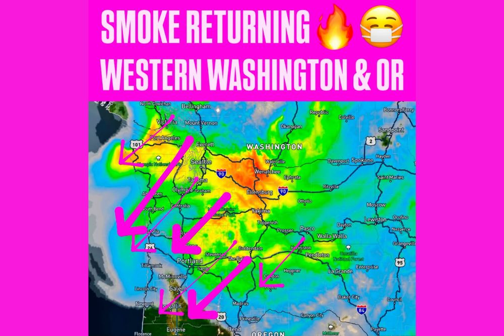
CONNECTICUT — A nasty line of storms is forecast to slide through Connecticut between 11 p.m. and 5 a.m., with possible severe weather overnight bringing wind, thunder, and heavy rain across much of the state. The timing is not great, since the storms may wake residents up, with a decent light show expected featuring frequent lightning, heavy rain, and even some strong wind gusts.

Danbury and New Haven See Most Intense Rainfall Cores

Radar-based rainfall projections show the most intense cores of heavy rain centered near Danbury, Monroe, and stretching down through New Haven, Bridgeport, and Stamford. These areas show the deepest red shading, indicating the highest rainfall rates within the overnight system.

Communities including Ridgefield, Southbury, and Guilford also fall within this intense southwestern corridor, where the combination of heavy rain and embedded thunderstorm activity poses the greatest overnight concern.

Hartford and Central Connecticut Face Widespread Storm Coverage

A broad area of storm coverage stretches across Hartford, New Britain, Middletown, and Waterbury, with widespread yellow and orange radar returns indicating significant rainfall intensity throughout central Connecticut during the overnight hours.

This central corridor sits directly within the primary path of the overnight line, meaning residents throughout the Hartford metro area should expect the full range of hazards, including thunder, wind, and heavy rain, as the system moves through between 11 p.m. and 5 a.m.

Eastern Connecticut Sees Storm Activity Extend Toward Rhode Island Border

The storm system continues extending east across Mansfield, Willimantic, and Norwich, with activity reaching toward Westerly and the Rhode Island border. While generally showing lighter coverage compared to the western half of the state, this eastern extent still falls within the overnight severe weather concern.

Communities including Killingly and Thompson near the Massachusetts border also fall within the broader area expected to see impacts as the line continues its overnight progression across the state.

Frequent Lightning and Strong Wind Gusts Expected Statewide

Beyond the heavy rainfall, the overnight line is expected to produce frequent lightning throughout its passage, along with strong wind gusts capable of reaching severe criteria in the stronger embedded cells. This combination raises the potential for scattered power outages and localized wind damage.

Residents throughout Connecticut are encouraged to stay weather aware overnight and are urged to share preparedness information with friends and family given the overnight timing that could catch many residents off guard while asleep.

Leave a Reply Cancel reply

Your email address will not be published. Required fields are marked *

Featured Articles

  • Wildfire Smoke Drifts Back Into Western Washington Tonight Spreading Toward Portland and Northwestern Oregon With Hazy Skies Through the Weekend

    Wildfire Smoke Drifts Back Into Western Washington Tonight Spreading Toward Portland and Northwestern Oregon With Hazy Skies Through the Weekend

    August 13, 2026
  • Active Monsoon Pattern Brings Flash Flood and Fire Weather Threats Across the West Thursday With Warnings Spanning Washington to Arizona

    Active Monsoon Pattern Brings Flash Flood and Fire Weather Threats Across the West Thursday With Warnings Spanning Washington to Arizona

    August 13, 2026
  • Perseid Meteor Shower Peaks Tonight Across Michigan With Up to One Hundred Meteors Per Hour Possible Under Clear Complete Darkness

    Perseid Meteor Shower Peaks Tonight Across Michigan With Up to One Hundred Meteors Per Hour Possible Under Clear Complete Darkness

    August 13, 2026
  • Another Round of Storms Fires Up in Dakotas and Tracks Toward Iowa and Illinois Thursday With Damaging Winds Between Nine AM and Two PM

    Another Round of Storms Fires Up in Dakotas and Tracks Toward Iowa and Illinois Thursday With Damaging Winds Between Nine AM and Two PM

    August 13, 2026
  • Multiple New Lightning-Sparked Wildfires Break Out East of the Cascades With Sinlahekin Fire Now Exceeding One Hundred Fifty Thousand Acres

    Multiple New Lightning-Sparked Wildfires Break Out East of the Cascades With Sinlahekin Fire Now Exceeding One Hundred Fifty Thousand Acres

    August 13, 2026

Search

Follow Us on

  • Facebook
  • X
  • Instagram
  • VK
  • Pinterest
  • Last.fm
  • TikTok
  • Telegram
  • WhatsApp
  • RSS Feed

Categories

  • Climate Forecast (24)

About Seven Lakes News

We cover the weather that changes your day: storm warnings, heat and cold advisories, flooding, snow, and the forecasts behind them. We are not the National Weather Service and we do not issue warnings. When severe weather is close, check weather.gov or your local NWS office before you act on anything you read here.

Latest Articles

  • Wildfire Smoke Drifts Back Into Western Washington Tonight Spreading Toward Portland and Northwestern Oregon With Hazy Skies Through the Weekend

    Wildfire Smoke Drifts Back Into Western Washington Tonight Spreading Toward Portland and Northwestern Oregon With Hazy Skies Through the Weekend

    August 13, 2026
  • Active Monsoon Pattern Brings Flash Flood and Fire Weather Threats Across the West Thursday With Warnings Spanning Washington to Arizona

    Active Monsoon Pattern Brings Flash Flood and Fire Weather Threats Across the West Thursday With Warnings Spanning Washington to Arizona

    August 13, 2026
  • Perseid Meteor Shower Peaks Tonight Across Michigan With Up to One Hundred Meteors Per Hour Possible Under Clear Complete Darkness

    Perseid Meteor Shower Peaks Tonight Across Michigan With Up to One Hundred Meteors Per Hour Possible Under Clear Complete Darkness

    August 13, 2026

Categories

  • Climate Forecast (24)
August 2026
M T W T F S S
 12
3456789
10111213141516
17181920212223
24252627282930
31  
     

© 2026 Seven Lakes News | All Rights Reserved.

Scroll to Top