
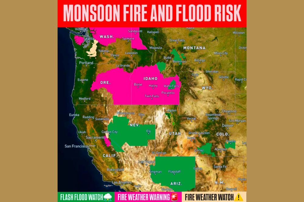
WEST — Thursday will be an active monsoon day across the West with a mix of wet and dry thunderstorms expected to trigger flash flooding and debris flows while also sparking new fires. Fire Weather Warnings, Flash Flood and Flood Watches, and Fire Weather Watches are all in effect simultaneously across a broad swath of the western United States.
Fire Weather Warnings Cover Oregon, Idaho, and Parts of Washington
The most serious Fire Weather Warnings stretch across Oregon and Idaho, including communities such as Boise, Hailey, Idaho Falls, Twin Falls, and Pocatello. A separate warning area covers portions of Washington State near Spokane and stretches into Montana near Bozeman.
These warnings reflect the highest level of concern for dry thunderstorms capable of sparking new wildfire starts, driven by lightning without significant accompanying rainfall across these areas Thursday.
Flash Flood Watches Span Nevada, Utah, Arizona, and New Mexico
Flash Flood Watches cover a large green-shaded area spanning much of Nevada, Utah, and Arizona, including Las Vegas, Flagstaff, Kingman, and Buckeye, along with portions of southern Colorado near Alamosa and northern New Mexico near Cortez.
This widespread flash flood concern reflects the wetter side of Thursday’s monsoon setup, where thunderstorms are expected to produce heavy rainfall capable of triggering rapid flooding and debris flows, particularly in areas with steep or burn-scarred terrain.
Fire Weather Watches Highlight Additional Concern Near Seattle
A Fire Weather Watch, shown in tan shading, covers a smaller area near Seattle and the Puget Sound region along with a portion of California near Sacramento. This watch-level designation indicates conditions favorable for fire weather concern, though not yet at warning criteria.
The presence of this watch alongside the more serious warnings farther inland illustrates how the broader monsoon-driven pattern is creating fire weather concern across a wide range of the West, not limited to the traditionally driest interior regions.
Mix of Wet and Dry Thunderstorms Creates Dual Hazard Setup
The defining feature of Thursday’s setup is the mix of wet and dry thunderstorms occurring simultaneously across different parts of the West. Wet thunderstorms are driving the flash flood and debris flow concern, while dry thunderstorms with limited rainfall are behind the fire weather warnings and watches.
Residents across the affected states, from Washington and Oregon through Idaho, Nevada, Utah, and Arizona, are encouraged to stay weather aware Thursday given the combination of flooding and fire ignition risks present across the region simultaneously.
Leave a Reply