Skip to content

Home

About Us

Contact Us

  • Facebook
  • X
  • Instagram
  • Pinterest
  • WhatsApp
  • RSS Feed
  • TikTok

Seven Lakes News

Your Trusted Voice Across the World.

Search

Another Round of Storms Fires Up in Dakotas and Tracks Toward Iowa and Illinois Thursday With Damaging Winds Between Nine AM and Two PM

Justin Lyle Avatar
Justin Lyle
August 13, 2026
Another Round of Storms Fires Up in Dakotas and Tracks Toward Iowa and Illinois Thursday With Damaging Winds Between Nine AM and Two PM

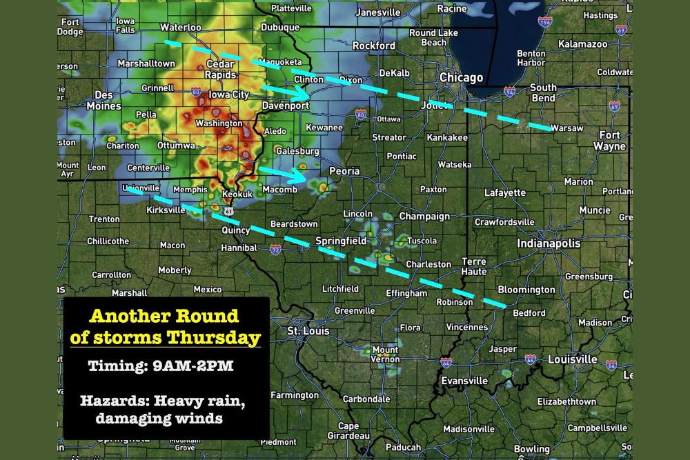
ILLINOIS — Another round of storms is developing in the Dakotas and heading toward Iowa and Illinois for Thursday morning, expected to be similar to storms that impacted the region earlier this week. A few storms will carry damaging winds and heavy rain, with timing running from 9 a.m. to 2 p.m. and an elevated but not high severe risk.

Storm Corridor Stretches From Cedar Rapids Through Peoria to Bloomington

The system is expected to track along a corridor from near Waterloo and Cedar Rapids in Iowa through Davenport, Galesburg, and Peoria in Illinois, before continuing toward Springfield and Bloomington. Communities within this dashed-line corridor should expect the strongest storms Thursday.

The southern edge of the projected strongest activity extends toward Quincy, Beardstown, and Effingham, while the northern edge tracks near DeKalb, Joliet, and Warsaw as the system continues its eastward push through the day.

Storms Expected to Be Strongest Between Marked Corridor Lines

Forecasters indicate storms should be strongest specifically between the two dashed lines marked on the outlook map, a corridor spanning roughly from central Iowa through central Illinois and into western Indiana near Fort Wayne and Bloomington, Indiana.

This band of highest concern reflects where the best combination of instability and forcing is expected to align Thursday, similar to the setup that produced damaging winds and heavy rain earlier in the week.

Not Expected to Be a Derecho but Gusty Shelf Cloud Possible

Forecasters were clear that Thursday’s system will not be a derecho, distinguishing it from some of the more significant wind events the region has experienced recently. However, the storms can still be gusty, with a pretty shelf cloud expected to accompany the leading edge of the activity.

This distinction is important for residents trying to gauge the relative severity of Thursday’s round compared to prior, more intense wind-driven events that have moved through the broader region this week.

Heavy Rain and Damaging Winds Remain Primary Hazards

The primary hazards for Thursday’s round remain heavy rain and damaging winds, consistent with the pattern of repeated storm systems that have tracked through Iowa and Illinois in recent days. The elevated but not high severe risk reflects a moderate level of confidence in stronger storm development.

Residents across Iowa and Illinois, including Cedar Rapids, Peoria, and Springfield, are encouraged to stay weather aware Thursday between 9 a.m. and 2 p.m. as this latest round of storms tracks through the region.
Leave a Reply Cancel reply

Your email address will not be published. Required fields are marked *

Featured Articles

  • Wildfire Smoke Drifts Back Into Western Washington Tonight Spreading Toward Portland and Northwestern Oregon With Hazy Skies Through the Weekend

    Wildfire Smoke Drifts Back Into Western Washington Tonight Spreading Toward Portland and Northwestern Oregon With Hazy Skies Through the Weekend

    August 13, 2026
  • Active Monsoon Pattern Brings Flash Flood and Fire Weather Threats Across the West Thursday With Warnings Spanning Washington to Arizona

    Active Monsoon Pattern Brings Flash Flood and Fire Weather Threats Across the West Thursday With Warnings Spanning Washington to Arizona

    August 13, 2026
  • Perseid Meteor Shower Peaks Tonight Across Michigan With Up to One Hundred Meteors Per Hour Possible Under Clear Complete Darkness

    Perseid Meteor Shower Peaks Tonight Across Michigan With Up to One Hundred Meteors Per Hour Possible Under Clear Complete Darkness

    August 13, 2026
  • Another Round of Storms Fires Up in Dakotas and Tracks Toward Iowa and Illinois Thursday With Damaging Winds Between Nine AM and Two PM

    Another Round of Storms Fires Up in Dakotas and Tracks Toward Iowa and Illinois Thursday With Damaging Winds Between Nine AM and Two PM

    August 13, 2026
  • Multiple New Lightning-Sparked Wildfires Break Out East of the Cascades With Sinlahekin Fire Now Exceeding One Hundred Fifty Thousand Acres

    Multiple New Lightning-Sparked Wildfires Break Out East of the Cascades With Sinlahekin Fire Now Exceeding One Hundred Fifty Thousand Acres

    August 13, 2026

Search

Follow Us on

  • Facebook
  • X
  • Instagram
  • VK
  • Pinterest
  • Last.fm
  • TikTok
  • Telegram
  • WhatsApp
  • RSS Feed

Categories

  • Climate Forecast (24)

About Seven Lakes News

We cover the weather that changes your day: storm warnings, heat and cold advisories, flooding, snow, and the forecasts behind them. We are not the National Weather Service and we do not issue warnings. When severe weather is close, check weather.gov or your local NWS office before you act on anything you read here.

Latest Articles

  • Wildfire Smoke Drifts Back Into Western Washington Tonight Spreading Toward Portland and Northwestern Oregon With Hazy Skies Through the Weekend

    Wildfire Smoke Drifts Back Into Western Washington Tonight Spreading Toward Portland and Northwestern Oregon With Hazy Skies Through the Weekend

    August 13, 2026
  • Active Monsoon Pattern Brings Flash Flood and Fire Weather Threats Across the West Thursday With Warnings Spanning Washington to Arizona

    Active Monsoon Pattern Brings Flash Flood and Fire Weather Threats Across the West Thursday With Warnings Spanning Washington to Arizona

    August 13, 2026
  • Perseid Meteor Shower Peaks Tonight Across Michigan With Up to One Hundred Meteors Per Hour Possible Under Clear Complete Darkness

    Perseid Meteor Shower Peaks Tonight Across Michigan With Up to One Hundred Meteors Per Hour Possible Under Clear Complete Darkness

    August 13, 2026

Categories

  • Climate Forecast (24)
August 2026
M T W T F S S
 12
3456789
10111213141516
17181920212223
24252627282930
31  
     

© 2026 Seven Lakes News | All Rights Reserved.

Scroll to Top