Skip to content

Home

About Us

Contact Us

  • Facebook
  • X
  • Instagram
  • Pinterest
  • WhatsApp
  • RSS Feed
  • TikTok

Seven Lakes News

Your Trusted Voice Across the World.

Search

Derecho Possibly Beginning With Eighty MPH Gusts Reported in Iowa as Powerful Bow Echo Tracks Toward Chicago and Northern Illinois This Morning

Justin Lyle Avatar
Justin Lyle
August 11, 2026
Derecho Possibly Beginning With Eighty MPH Gusts Reported in Iowa as Powerful Bow Echo Tracks Toward Chicago and Northern Illinois This Morning

ILLINOIS — A derecho is possibly beginning on schedule Tuesday morning, with 75 mph wind gusts already noted in Independence, Iowa, and an 80 mph report in Farley from this compact but very powerful bow echo. The projected path will bring the system toward the Chicago area, with many severe and tornado warnings already issued as the morning progresses.

Compact Bow Echo Already Producing Damaging Wind Reports

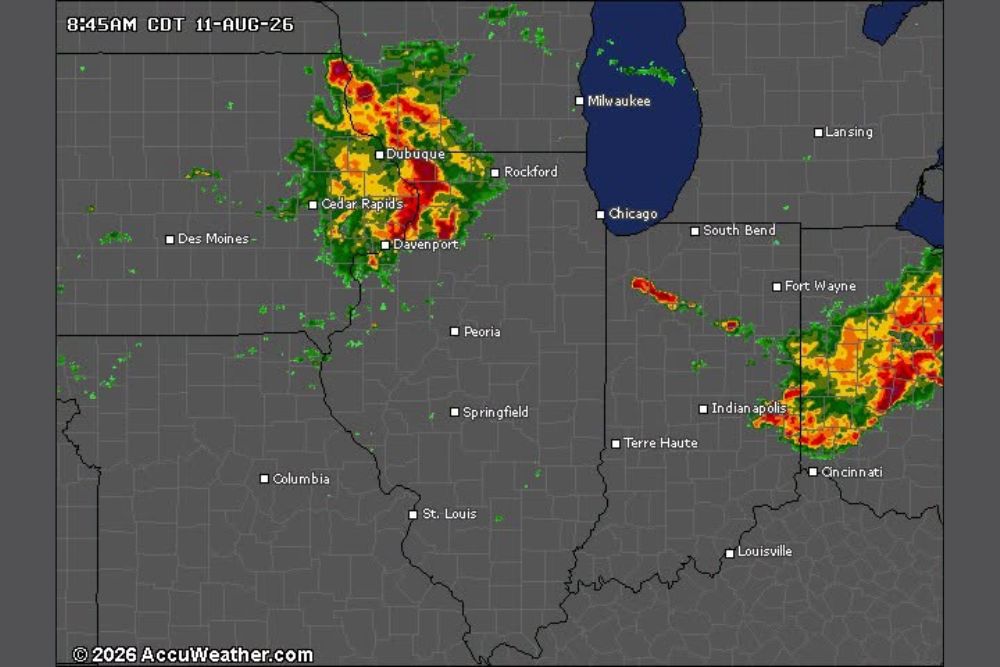
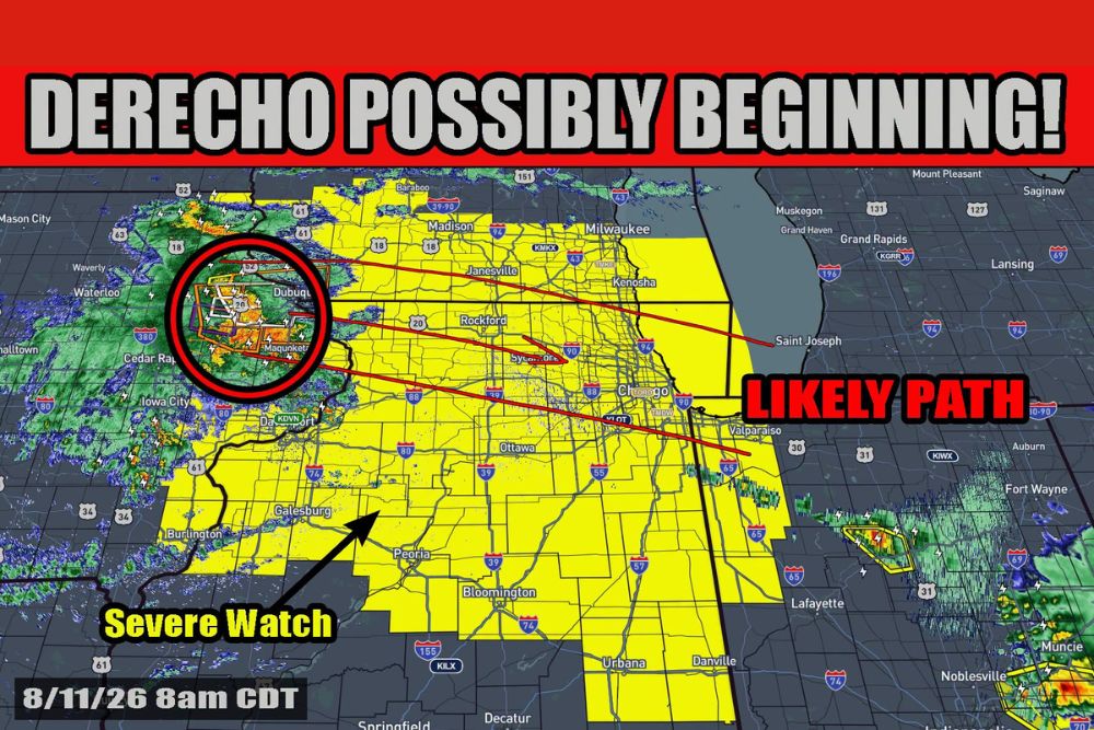
The bow echo responsible for the developing derecho is currently centered near Dubuque, Iowa, with radar showing an intense, well-organized core within a circled area of highest concern. The system has already produced 75 mph gusts in Independence and an 80 mph report in Farley.

Despite its power, forecasters describe the system as compact rather than a broad squall line at this stage, though its intensity has already proven capable of significant wind damage across northeast Iowa.

Sun Building Instability Ahead of System Through Morning

With the sun now up, quick work is expected building instability across the swampy airmass positioned out ahead of the system. This developing instability should allow for at least maintenance of the bow echo’s current strength, with possible additional strengthening as the morning progresses.

This daytime heating process is a key factor forecasters are watching, since it directly influences whether the system will hold its current intensity or continue to intensify as it tracks toward more populated areas.

Severe Thunderstorm Watch Covers Corridor Toward Chicago and Indiana

A Severe Thunderstorm Watch spans a broad corridor from Waterloo and Dubuque through Rockford, Chicago, and continuing into Bloomington, Danville, and toward the Indiana state line. The likely path for the bow echo runs directly through Rockford and Chicago before continuing toward Valparaiso and Fort Wayne.

Communities within this watch area, including Peoria, Ottawa, and the greater Chicago metro, should prepare for the possibility of significant wind gusts as the system continues along its projected eastward track.

Uncertainty Remains Over Whether System Expands Into Squall Line

What remains to be seen is whether the system will expand into more of a large squall line or remain a compact bow echo as it continues its journey east. This distinction matters significantly for how widespread the eventual wind damage footprint could become.

Residents across northern Illinois, particularly in and around Chicago, are urged to stay weather aware through the morning as many severe and tornado warnings have already been issued and are expected to continue as the system approaches.
Leave a Reply Cancel reply

Your email address will not be published. Required fields are marked *

Featured Articles

  • Damaging Line of Storms Sweeps From Fort Wayne Through Indianapolis and Dayton With Elevated Wind Gusts Up to Seventy MPH and Inch-Size Hail

    Damaging Line of Storms Sweeps From Fort Wayne Through Indianapolis and Dayton With Elevated Wind Gusts Up to Seventy MPH and Inch-Size Hail

    August 11, 2026
  • Derecho Possibly Beginning With Eighty MPH Gusts Reported in Iowa as Powerful Bow Echo Tracks Toward Chicago and Northern Illinois This Morning

    Derecho Possibly Beginning With Eighty MPH Gusts Reported in Iowa as Powerful Bow Echo Tracks Toward Chicago and Northern Illinois This Morning

    August 11, 2026
  • One in Two Hundred Year Flooding Event Slams Southern Somerset County With Four to Six Inches of Rain Triggering Road Closures and Flooded Homes

    One in Two Hundred Year Flooding Event Slams Southern Somerset County With Four to Six Inches of Rain Triggering Road Closures and Flooded Homes

    August 11, 2026
  • Fast-Moving Storm Complex Races Into Northwest Illinois at Fifty Miles Per Hour as Forecasters Watch for New Storms Along Outflow Boundary

    Fast-Moving Storm Complex Races Into Northwest Illinois at Fifty Miles Per Hour as Forecasters Watch for New Storms Along Outflow Boundary

    August 11, 2026
  • Damaging Wind Gusts Threaten Atlanta and North Georgia This Afternoon and Evening as More Organized Severe Weather Stays North of Region

    Damaging Wind Gusts Threaten Atlanta and North Georgia This Afternoon and Evening as More Organized Severe Weather Stays North of Region

    August 11, 2026

Search

Follow Us on

  • Facebook
  • X
  • Instagram
  • VK
  • Pinterest
  • Last.fm
  • TikTok
  • Telegram
  • WhatsApp
  • RSS Feed

Categories

  • Climate Forecast (8)

About Seven Lakes News

We cover the weather that changes your day: storm warnings, heat and cold advisories, flooding, snow, and the forecasts behind them. We are not the National Weather Service and we do not issue warnings. When severe weather is close, check weather.gov or your local NWS office before you act on anything you read here.

Latest Articles

  • Damaging Line of Storms Sweeps From Fort Wayne Through Indianapolis and Dayton With Elevated Wind Gusts Up to Seventy MPH and Inch-Size Hail

    Damaging Line of Storms Sweeps From Fort Wayne Through Indianapolis and Dayton With Elevated Wind Gusts Up to Seventy MPH and Inch-Size Hail

    August 11, 2026
  • Derecho Possibly Beginning With Eighty MPH Gusts Reported in Iowa as Powerful Bow Echo Tracks Toward Chicago and Northern Illinois This Morning

    Derecho Possibly Beginning With Eighty MPH Gusts Reported in Iowa as Powerful Bow Echo Tracks Toward Chicago and Northern Illinois This Morning

    August 11, 2026
  • One in Two Hundred Year Flooding Event Slams Southern Somerset County With Four to Six Inches of Rain Triggering Road Closures and Flooded Homes

    One in Two Hundred Year Flooding Event Slams Southern Somerset County With Four to Six Inches of Rain Triggering Road Closures and Flooded Homes

    August 11, 2026

Categories

  • Climate Forecast (8)
August 2026
M T W T F S S
 12
3456789
10111213141516
17181920212223
24252627282930
31  
     

© 2026 Seven Lakes News | All Rights Reserved.

Scroll to Top