
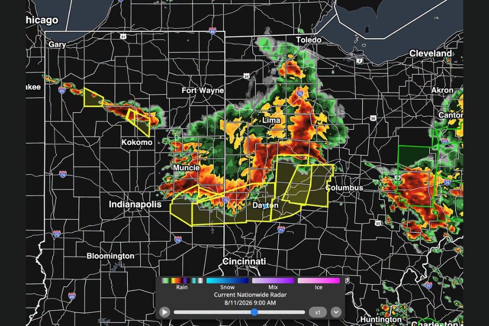
INDIANA — A damaging line of thunderstorms tracked across Indiana and into Ohio Tuesday morning, stretching from near Fort Wayne and Kokomo through Muncie, Indianapolis, and Dayton before continuing toward Columbus. Warning polygons covered a broad swath of the corridor as the line moved through, bringing heavy rain, lightning, and severe wind gusts with an isolated tornado also possible.
Line Tracks From Kokomo Through Indianapolis Into Ohio
Radar imagery captured Tuesday morning shows an extensive line of storms stretching from near Kokomo and Fort Wayne southeast through Muncie, Indianapolis, and Dayton, with additional intense activity continuing toward Columbus. Multiple warning polygons were active across this corridor as the system progressed.
The line maintained a well-organized structure across its full length, with the most intense radar returns concentrated over the Indianapolis to Dayton stretch as the system continued its eastward and southeastward push through the morning.
Elevated Wind Gust Risk Highlighted Near Marion and Muncie
A forecast nowcast graphic highlighted a pink circled area covering Marion and extending toward Muncie and Richmond as the zone carrying the highest risk for elevated wind gusts of 60 to 70-plus mph and hail up to 1 inch in diameter.
Timing guidance placed the strongest activity moving through this circled zone between roughly 8:40 a.m. and 9:40 a.m., with the broader line continuing to track southeast toward Springfield and Dayton in the following hour.
Heavy Rain and Lightning Accompany Line Across Corridor
Beyond the wind and hail threat, the line brought streaks of 1 inch or more of rainfall likely across much of its path, along with frequent lightning throughout the system. This combination of hazards affected communities across the full corridor from Fort Wayne through Dayton.
An isolated tornado also remained possible with the stronger embedded cells within the line, adding another hazard for residents to monitor as the system moved through central Indiana and into western Ohio.
Forecast Nowcast Accurately Anticipated Timing and Track
Forecasters noted that many weather apps rely on the HRRR model for future radar projections, but the model’s 9 a.m. simulated radar did not match what actually developed, a damaging line of thunderstorms. A detailed nowcast issued ahead of time accurately pinpointed where the line would track and when it would arrive.
Residents across Indiana and western Ohio, including Indianapolis, Muncie, and Dayton, are encouraged to continue monitoring updated forecasts throughout the day as additional rounds of storms remain possible.
Leave a Reply