
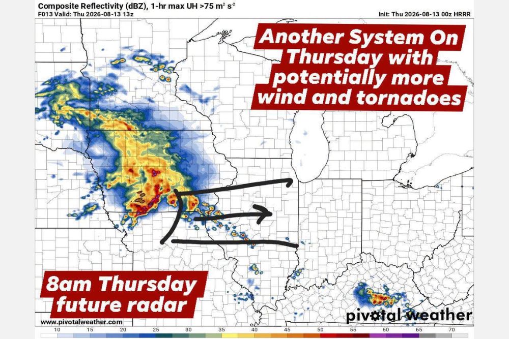
ILLINOIS — Another chance for a strong Mesoscale Convective System exists as the complex moves from Iowa into Illinois Thursday late morning and early afternoon. Models currently keep the strongest winds with the bow echo positioned south of Interstate 80 across central Illinois into central Indiana, with damaging wind gusts and tornadoes once again possible with the strongest part of the system.
Future Radar Shows Complex Positioned Over Central Illinois by Eight AM
Simulated radar valid for 8 a.m. Thursday shows an intense, well-organized complex centered over central Illinois, with the heaviest core of activity, shown in orange and red returns, positioned across a broad swath of the state’s midsection.
An estimated forward track carries the strongest segment of the system southeast from central Illinois toward the Indiana border, consistent with the general track models are currently favoring for the strongest winds within the broader complex.
Strongest Winds Expected to Track South of Interstate 80
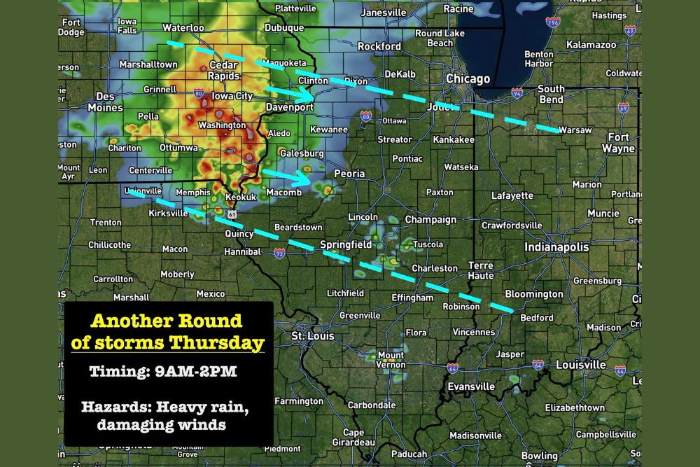
At this time, models keep the strongest winds associated with the bow echo positioned south of Interstate 80, spanning a corridor across central Illinois and continuing into central Indiana. This placement would keep the most intense wind threat away from the Chicago metro area to the north.
Forecasters caution this remains just a general idea on the track and is not a given, meaning the exact positioning of the strongest winds could shift as the system continues developing through Wednesday night into Thursday morning.
Damaging Wind Gusts and Tornadoes Possible With Strongest Segment
As has been the pattern with recent systems, damaging wind gusts and tornadoes are once again possible with the strongest part of Thursday’s complex. This repeat threat profile continues an active stretch of severe weather potential across the region.
The combination of these hazards means communities across central Illinois and into central Indiana should prepare for the possibility of both significant wind damage and isolated tornado activity as the system tracks through during the late morning and early afternoon hours.
Timing for Illinois Runs From Nine AM Through Two PM
Current timing guidance places the window of greatest concern for Illinois between 9 a.m. and 2 p.m. Thursday, as the complex moves through the state during the late morning and into the early afternoon hours.
Residents across central Illinois and central Indiana are encouraged to monitor updates throughout Wednesday night and Thursday morning, since forecasters plan to continue refining the track and timing as the system develops and moves eastward out of Iowa.

Leave a Reply