
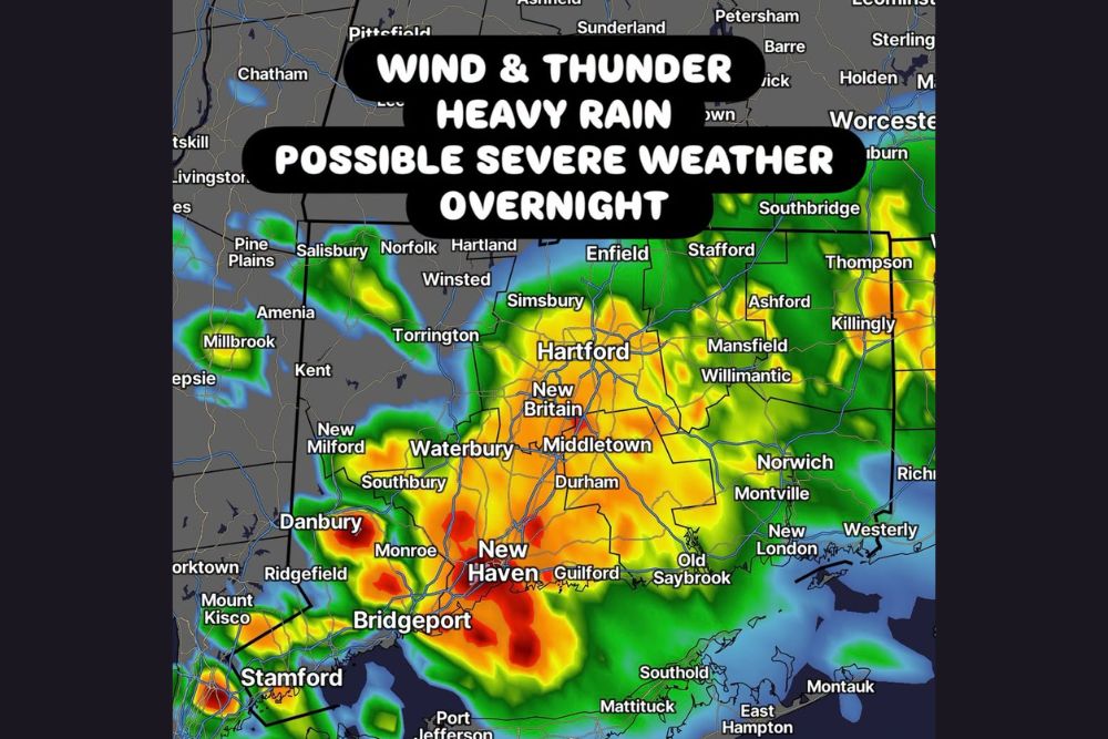
CONNECTICUT — A nasty line of storms is forecast to slide through Connecticut between 11 p.m. and 5 a.m., with possible severe weather overnight bringing wind, thunder, and heavy rain across much of the state. The timing is not great, since the storms may wake residents up, with a decent light show expected featuring frequent lightning, heavy rain, and even some strong wind gusts.
Danbury and New Haven See Most Intense Rainfall Cores
Radar-based rainfall projections show the most intense cores of heavy rain centered near Danbury, Monroe, and stretching down through New Haven, Bridgeport, and Stamford. These areas show the deepest red shading, indicating the highest rainfall rates within the overnight system.
Communities including Ridgefield, Southbury, and Guilford also fall within this intense southwestern corridor, where the combination of heavy rain and embedded thunderstorm activity poses the greatest overnight concern.
Hartford and Central Connecticut Face Widespread Storm Coverage
A broad area of storm coverage stretches across Hartford, New Britain, Middletown, and Waterbury, with widespread yellow and orange radar returns indicating significant rainfall intensity throughout central Connecticut during the overnight hours.
This central corridor sits directly within the primary path of the overnight line, meaning residents throughout the Hartford metro area should expect the full range of hazards, including thunder, wind, and heavy rain, as the system moves through between 11 p.m. and 5 a.m.
Eastern Connecticut Sees Storm Activity Extend Toward Rhode Island Border
The storm system continues extending east across Mansfield, Willimantic, and Norwich, with activity reaching toward Westerly and the Rhode Island border. While generally showing lighter coverage compared to the western half of the state, this eastern extent still falls within the overnight severe weather concern.
Communities including Killingly and Thompson near the Massachusetts border also fall within the broader area expected to see impacts as the line continues its overnight progression across the state.
Frequent Lightning and Strong Wind Gusts Expected Statewide
Beyond the heavy rainfall, the overnight line is expected to produce frequent lightning throughout its passage, along with strong wind gusts capable of reaching severe criteria in the stronger embedded cells. This combination raises the potential for scattered power outages and localized wind damage.
Residents throughout Connecticut are encouraged to stay weather aware overnight and are urged to share preparedness information with friends and family given the overnight timing that could catch many residents off guard while asleep.


Leave a Reply