Skip to content

Home

About Us

Contact Us

  • Facebook
  • X
  • Instagram
  • Pinterest
  • WhatsApp
  • RSS Feed
  • TikTok

Seven Lakes News

Your Trusted Voice Across the World.

Search

Fast-Moving Storm Complex Races Into Northwest Illinois at Fifty Miles Per Hour as Forecasters Watch for New Storms Along Outflow Boundary

Justin Lyle Avatar
Justin Lyle
August 11, 2026
Fast-Moving Storm Complex Races Into Northwest Illinois at Fifty Miles Per Hour as Forecasters Watch for New Storms Along Outflow Boundary

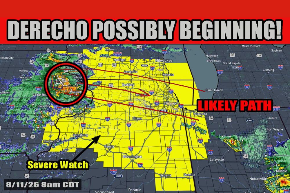
ILLINOIS — A large area of storms known as a Mesoscale Convective Complex is moving out of Iowa and into northwest Illinois, prompting a Severe Thunderstorm Watch across the region. This cluster of storms is currently moving east at 50 mph and should continue that movement for a while before turning southeast, meaning the complex itself should stay mostly to the north and northeast of the broader Illinois area.

Severe Thunderstorm Watch 563 Covers Corridor Through Two P.M.

Severe Thunderstorm Watch 563 is valid from 7:20 a.m. until 2 p.m., covering a corridor stretching from Mason City and Waterloo through Dubuque, Rockford, and down through Peoria and toward Lafayette and Champaign. Current radar shows the strongest core of the complex positioned near Dubuque and Cedar Rapids.

The fast eastward movement at 50 mph means this initial round should progress through the watch area relatively quickly, though the complex’s broader influence on the atmosphere is expected to continue well beyond its own passage.

Outflow Boundary Could Spark New Storms This Afternoon

Forecasters will be watching for what is called an outflow boundary to potentially form out of this complex to the south of its movement. An outflow boundary is essentially a small cold front caused by cooler air rushing out of the complex, and these boundaries can trigger new storm development.

If an outflow boundary does form, that will become the primary focus for storms developing by this afternoon, shifting attention away from the original complex and toward newly forming activity along the boundary itself.

Simulated Radar Shows New Storms Developing by Four PM

Forecast radar valid for 4 p.m. Tuesday shows the potential for new storms developing along an outflow boundary, positioned separately from the location of the original storm complex. This simulated guidance illustrates how the boundary mechanism could spark fresh convection later in the day.

By 5 p.m. and 6 p.m., the simulated radar shows this new activity continuing to expand and organize, suggesting the outflow-driven storms could become a more significant feature of the afternoon and evening forecast.

Residents Urged to Stay Weather Aware Through the Afternoon

While the original complex is expected to track mostly north and northeast of the immediate area, the potential for new storm development along an outflow boundary means the overall severe weather picture remains fluid heading into the afternoon.

Residents throughout the watch area, including Rockford, Peoria, and Springfield, are encouraged to stay weather aware today as forecasters continue monitoring how the outflow boundary situation develops through the afternoon hours.
Leave a Reply Cancel reply

Your email address will not be published. Required fields are marked *

Featured Articles

  • Damaging Line of Storms Sweeps From Fort Wayne Through Indianapolis and Dayton With Elevated Wind Gusts Up to Seventy MPH and Inch-Size Hail

    Damaging Line of Storms Sweeps From Fort Wayne Through Indianapolis and Dayton With Elevated Wind Gusts Up to Seventy MPH and Inch-Size Hail

    August 11, 2026
  • Derecho Possibly Beginning With Eighty MPH Gusts Reported in Iowa as Powerful Bow Echo Tracks Toward Chicago and Northern Illinois This Morning

    Derecho Possibly Beginning With Eighty MPH Gusts Reported in Iowa as Powerful Bow Echo Tracks Toward Chicago and Northern Illinois This Morning

    August 11, 2026
  • One in Two Hundred Year Flooding Event Slams Southern Somerset County With Four to Six Inches of Rain Triggering Road Closures and Flooded Homes

    One in Two Hundred Year Flooding Event Slams Southern Somerset County With Four to Six Inches of Rain Triggering Road Closures and Flooded Homes

    August 11, 2026
  • Fast-Moving Storm Complex Races Into Northwest Illinois at Fifty Miles Per Hour as Forecasters Watch for New Storms Along Outflow Boundary

    Fast-Moving Storm Complex Races Into Northwest Illinois at Fifty Miles Per Hour as Forecasters Watch for New Storms Along Outflow Boundary

    August 11, 2026
  • Damaging Wind Gusts Threaten Atlanta and North Georgia This Afternoon and Evening as More Organized Severe Weather Stays North of Region

    Damaging Wind Gusts Threaten Atlanta and North Georgia This Afternoon and Evening as More Organized Severe Weather Stays North of Region

    August 11, 2026

Search

Follow Us on

  • Facebook
  • X
  • Instagram
  • VK
  • Pinterest
  • Last.fm
  • TikTok
  • Telegram
  • WhatsApp
  • RSS Feed

Categories

  • Climate Forecast (8)

About Seven Lakes News

We cover the weather that changes your day: storm warnings, heat and cold advisories, flooding, snow, and the forecasts behind them. We are not the National Weather Service and we do not issue warnings. When severe weather is close, check weather.gov or your local NWS office before you act on anything you read here.

Latest Articles

  • Damaging Line of Storms Sweeps From Fort Wayne Through Indianapolis and Dayton With Elevated Wind Gusts Up to Seventy MPH and Inch-Size Hail

    Damaging Line of Storms Sweeps From Fort Wayne Through Indianapolis and Dayton With Elevated Wind Gusts Up to Seventy MPH and Inch-Size Hail

    August 11, 2026
  • Derecho Possibly Beginning With Eighty MPH Gusts Reported in Iowa as Powerful Bow Echo Tracks Toward Chicago and Northern Illinois This Morning

    Derecho Possibly Beginning With Eighty MPH Gusts Reported in Iowa as Powerful Bow Echo Tracks Toward Chicago and Northern Illinois This Morning

    August 11, 2026
  • One in Two Hundred Year Flooding Event Slams Southern Somerset County With Four to Six Inches of Rain Triggering Road Closures and Flooded Homes

    One in Two Hundred Year Flooding Event Slams Southern Somerset County With Four to Six Inches of Rain Triggering Road Closures and Flooded Homes

    August 11, 2026

Categories

  • Climate Forecast (8)
August 2026
M T W T F S S
 12
3456789
10111213141516
17181920212223
24252627282930
31  
     

© 2026 Seven Lakes News | All Rights Reserved.

Scroll to Top