
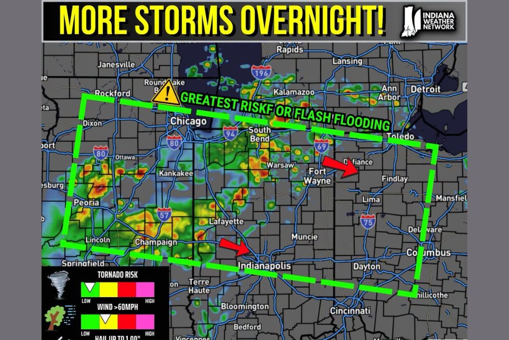
INDIANA — More rain is expected overnight tonight into tomorrow over the same areas that have already seen repeated rounds this week, with some areas possibly seeing an additional 1 to 3 inches of rain by tomorrow afternoon. Some storms may produce strong to damaging winds, though the renewed flooding risk remains the primary concern at this time.
Greatest Flash Flood Risk Corridor Stretches From Rockford to Toledo
The area of greatest risk for flash flooding is outlined in a broad corridor stretching from near Rockford and Chicago through South Bend, Fort Wayne, and Toledo. This zone represents where forecasters have the highest confidence in significant flooding impacts from the overnight and morning rainfall.
Radar shows widespread heavy rain already covering much of this corridor, with the most intense returns concentrated near Peoria, Kankakee, and stretching through central Indiana toward Fort Wayne as the system continues developing.
One to Three Inches of Additional Rain Possible by Afternoon
Some areas within the highlighted corridor may see an additional 1 to 3 inches of rain by tomorrow afternoon, adding to already saturated ground from the repeated rounds of storms that have affected the region throughout the week.
This additional rainfall total raises significant concern for continued flash flooding, particularly in communities that have already experienced multiple rounds of heavy rain and may have limited capacity to absorb further precipitation.
Strong to Damaging Winds Possible Though Flooding Remains Top Concern
While some storms may produce strong to damaging winds as they move through the corridor overnight, forecasters emphasized that the renewed flooding risk remains the primary concern at this time compared to other potential severe weather hazards.
The risk category graphic shows flash flood risk elevated toward the higher end of the scale, while tornado risk, wind over 60 mph, and hail up to 1 inch all remain at lower levels, reinforcing that flooding is the dominant hazard for this event.
Break From Rain Expected Early Next Week
Despite the continued overnight and morning threat, forecasters do look to have a break from the rain early this upcoming week, offering some relief on the horizon following what has been an extended stretch of active weather across Indiana and surrounding areas.
Residents throughout the corridor from Chicago through South Bend, Fort Wayne, and Toledo are urged to stay weather aware overnight and avoid flooded roadways as this latest round of heavy rain moves through before the anticipated drier pattern arrives next week.

Leave a Reply