
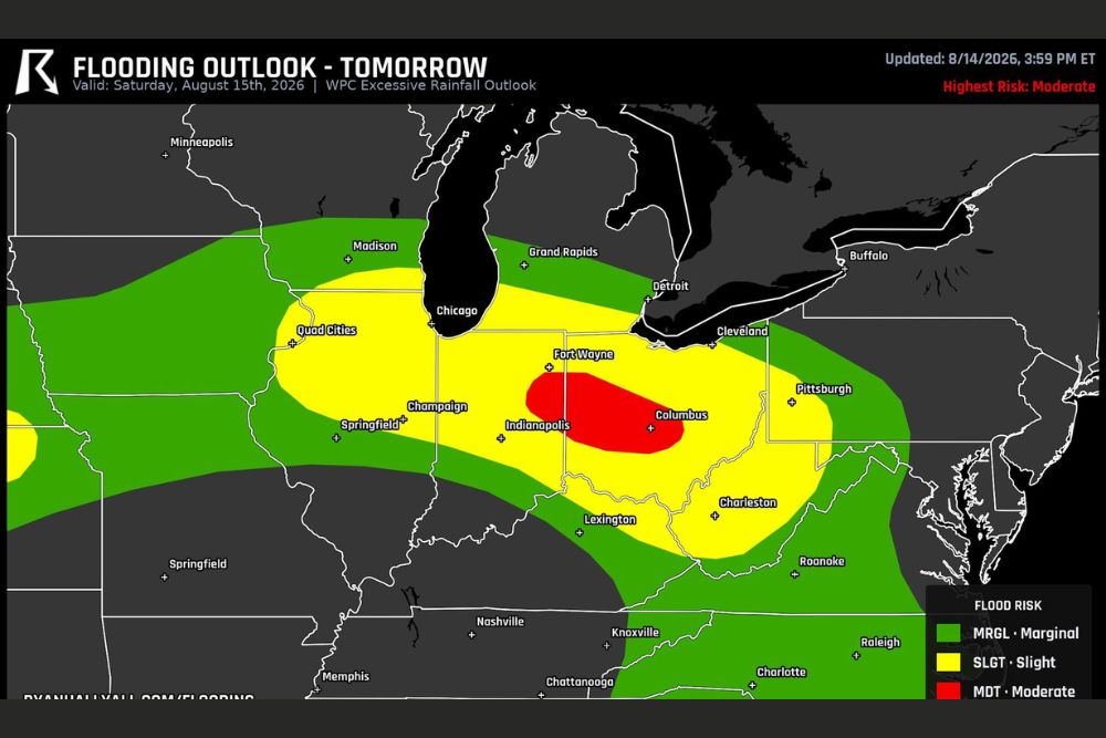
OHIO — Ohio and Indiana just moved up to the Weather Prediction Center’s Moderate flood risk category for Saturday, one step above where the outlook had them sitting Thursday morning. That upgrade covers roughly 3.6 million people, including Columbus, Dayton, Springfield, Muncie, and Lima.
Moderate Risk Zone Centers on Columbus and Fort Wayne Corridor
The Moderate flood risk area, shown in red on the WPC Excessive Rainfall Outlook, is centered directly over Columbus and extends toward Fort Wayne. This represents the highest risk category on Saturday’s flooding outlook, reflecting the greatest confidence in flooding impacts within this corridor.
A much broader Slight risk zone, shown in yellow, surrounds the Moderate area and stretches from the Quad Cities and Champaign through Indianapolis, Charleston, and toward Lexington, covering a wide swath of the Ohio Valley and Midwest.
Forty Percent Threshold Reflects Rain Outrunning Drainage Capacity
WPC’s Moderate category is built around a 40 percent or higher chance that rain rates in the affected area outrun what the drains and small creeks can carry off. This threshold represents a significant escalation in confidence compared to the Slight risk category surrounding it.
If storms line up and repeat over the Columbus and Fort Wayne region Saturday, that is the kind of setup that turns an ordinary summer rain into fast flooding on low roads and underpasses, according to forecasters tracking the upgraded outlook.
3.6 Million People Now Included Within Upgraded Risk Area
The upgrade to Moderate risk affects a population of roughly 3.6 million people, spanning communities including Columbus, Dayton, Springfield, Muncie, and Lima. This represents a substantial population base now facing the more serious end of Saturday’s flooding threat.
Communities within the broader Slight risk zone, including Indianapolis, Champaign, and Pittsburgh, also face meaningful flooding potential, though at a somewhat lower confidence level compared to the Moderate zone centered over Columbus.
Saturday Travel Plans Through Ohio and Indiana Warrant Extra Caution
Given the upgraded risk, it is worth building some slack into Saturday plans for anyone heading through the affected part of Ohio or Indiana. Fast-developing flooding on low roads and underpasses can create hazardous and unpredictable travel conditions with little advance warning.
Residents throughout Ohio and Indiana, particularly in and around Columbus, Dayton, and Fort Wayne, are encouraged to monitor the forecast closely Saturday and avoid driving through flooded roadways if repeating storms develop as outlined in the updated flooding outlook.
Leave a Reply