Skip to content

Home

About Us

Contact Us

  • Facebook
  • X
  • Instagram
  • Pinterest
  • WhatsApp
  • RSS Feed
  • TikTok

Seven Lakes News

Your Trusted Voice Across the World.

Search

Historic One in a Thousand Year Flooding Devastates Central Indiana as White River Surges Past Muncie and Anderson With Fifteen Plus Inches of Rain

Justin Lyle Avatar
Justin Lyle
August 14, 2026
Historic One in a Thousand Year Flooding Devastates Central Indiana as White River Surges Past Muncie and Anderson With Fifteen Plus Inches of Rain

INDIANA — A historic 1-in-1,000-year rainfall event is unfolding across parts of central and east-central Indiana, where locally more than 15 inches of rain has been reported over the past few days. The tremendous amount of rainfall has sent the White River into record flooding from Muncie to Anderson, inundating roads, neighborhoods, and low-lying areas throughout the region.

White River Reaches Record Flooding Stage Between Muncie and Anderson

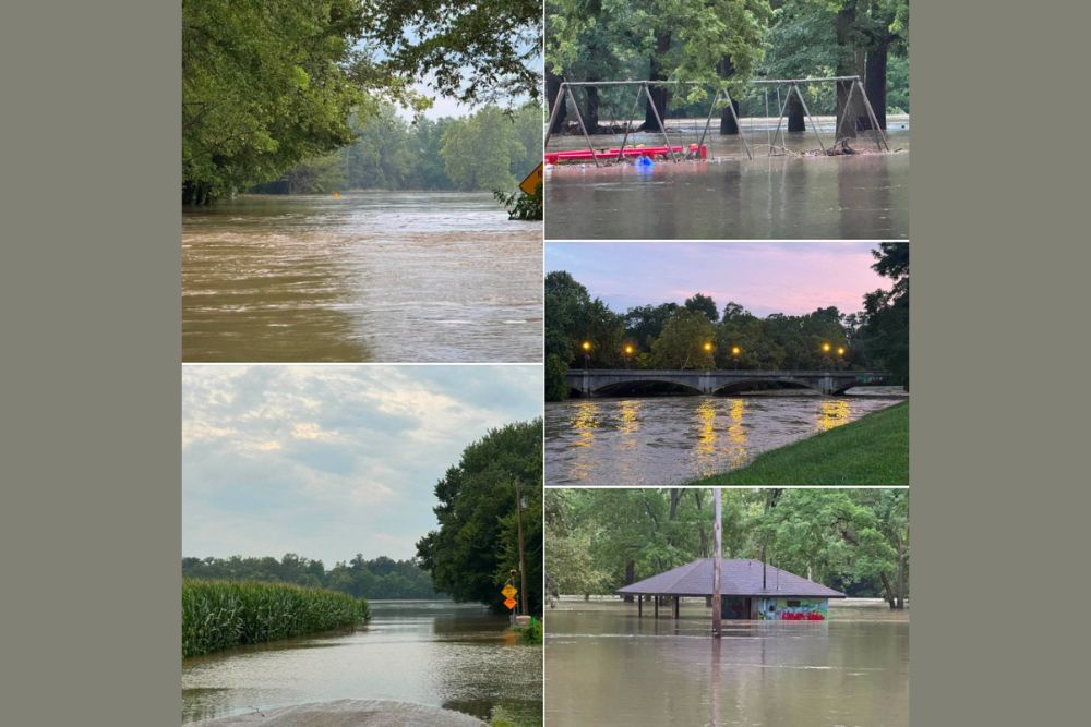
The White River has surged into record flooding along its stretch between Muncie and Anderson, with photos showing playground equipment and pavilions submerged well above their normal ground level. This unprecedented rise reflects the extraordinary volume of rainfall that has fallen across the watershed.

Communities along this corridor have seen extensive inundation, with roads and neighborhoods swallowed by rising water as the river continues responding to the historic rainfall totals reported over the past several days.

More Than Fifteen Inches of Rain Reported in Isolated Locations

Locally, more than 15 inches of rain has been reported across the hardest-hit areas of central and east-central Indiana, a staggering total that places this event firmly in the 1-in-1,000-year rainfall category based on historical statistical analysis for the region.

This magnitude of rainfall over such a short multi-day period has overwhelmed the White River and surrounding drainage systems, leading directly to the widespread and severe flooding now being documented across affected communities.

Roads, Neighborhoods, and Low-Lying Areas Inundated

Widespread inundation has affected roads, neighborhoods, and low-lying areas throughout the region, with photos showing farm fields submerged and roadways completely covered by floodwater. The extent of the flooding reflects just how much water the White River watershed has had to absorb.

Bridges and parks along the river corridor have also seen significant impacts, with normally dry recreational areas and structures now surrounded by or partially submerged in floodwater as the river remains well above its banks.

Downstream Impacts Could Continue as Water Continues Moving

Flooding remains dangerous across portions of Indiana, and additional impacts along rivers and streams could continue as all of that water works its way downstream. This means communities farther along the White River’s path should remain alert even as the immediate flooding begins to shift.

Residents throughout central and east-central Indiana, including Muncie and Anderson, are urged to avoid flooded roadways and low-lying areas as recovery efforts begin and river levels continue responding to this historic rainfall event.
Leave a Reply Cancel reply

Your email address will not be published. Required fields are marked *

Featured Articles

  • Dangerous Rotation Near Logansport Prompts Urgent Shelter Warning as Meteorologists Voice Deep Concern for Indiana Communities Southeast of Storm

    Dangerous Rotation Near Logansport Prompts Urgent Shelter Warning as Meteorologists Voice Deep Concern for Indiana Communities Southeast of Storm

    August 14, 2026
  • Flash Flood Warning Issued for Little Giant Burn Scar in Central Chelan County as Mud Slides Threaten Silver Falls and Fox Creek Campgrounds

    Flash Flood Warning Issued for Little Giant Burn Scar in Central Chelan County as Mud Slides Threaten Silver Falls and Fox Creek Campgrounds

    August 14, 2026
  • Damaging Microburst Downs Trees and Closes Multiple Roads Between Mineral Springs and Monroe in Union County North Carolina Thursday Evening

    Damaging Microburst Downs Trees and Closes Multiple Roads Between Mineral Springs and Monroe in Union County North Carolina Thursday Evening

    August 14, 2026
  • Flash Flood Warning Issued for Five Illinois Counties Until Three AM as Storms Drop Two Inches With Another Two Inches Expected Overnight

    Flash Flood Warning Issued for Five Illinois Counties Until Three AM as Storms Drop Two Inches With Another Two Inches Expected Overnight

    August 14, 2026
  • Deep Partial Lunar Eclipse Coming August 27 Will Cover Ninety-Three Percent of Moon With Dark Red and Copper Colors Visible Across United States

    Deep Partial Lunar Eclipse Coming August 27 Will Cover Ninety-Three Percent of Moon With Dark Red and Copper Colors Visible Across United States

    August 14, 2026

Search

Follow Us on

  • Facebook
  • X
  • Instagram
  • VK
  • Pinterest
  • Last.fm
  • TikTok
  • Telegram
  • WhatsApp
  • RSS Feed

Categories

  • Climate Forecast (32)

About Seven Lakes News

We cover the weather that changes your day: storm warnings, heat and cold advisories, flooding, snow, and the forecasts behind them. We are not the National Weather Service and we do not issue warnings. When severe weather is close, check weather.gov or your local NWS office before you act on anything you read here.

Latest Articles

  • Dangerous Rotation Near Logansport Prompts Urgent Shelter Warning as Meteorologists Voice Deep Concern for Indiana Communities Southeast of Storm

    Dangerous Rotation Near Logansport Prompts Urgent Shelter Warning as Meteorologists Voice Deep Concern for Indiana Communities Southeast of Storm

    August 14, 2026
  • Flash Flood Warning Issued for Little Giant Burn Scar in Central Chelan County as Mud Slides Threaten Silver Falls and Fox Creek Campgrounds

    Flash Flood Warning Issued for Little Giant Burn Scar in Central Chelan County as Mud Slides Threaten Silver Falls and Fox Creek Campgrounds

    August 14, 2026
  • Damaging Microburst Downs Trees and Closes Multiple Roads Between Mineral Springs and Monroe in Union County North Carolina Thursday Evening

    Damaging Microburst Downs Trees and Closes Multiple Roads Between Mineral Springs and Monroe in Union County North Carolina Thursday Evening

    August 14, 2026

Categories

  • Climate Forecast (32)
August 2026
M T W T F S S
 12
3456789
10111213141516
17181920212223
24252627282930
31  
     

© 2026 Seven Lakes News | All Rights Reserved.

Scroll to Top