
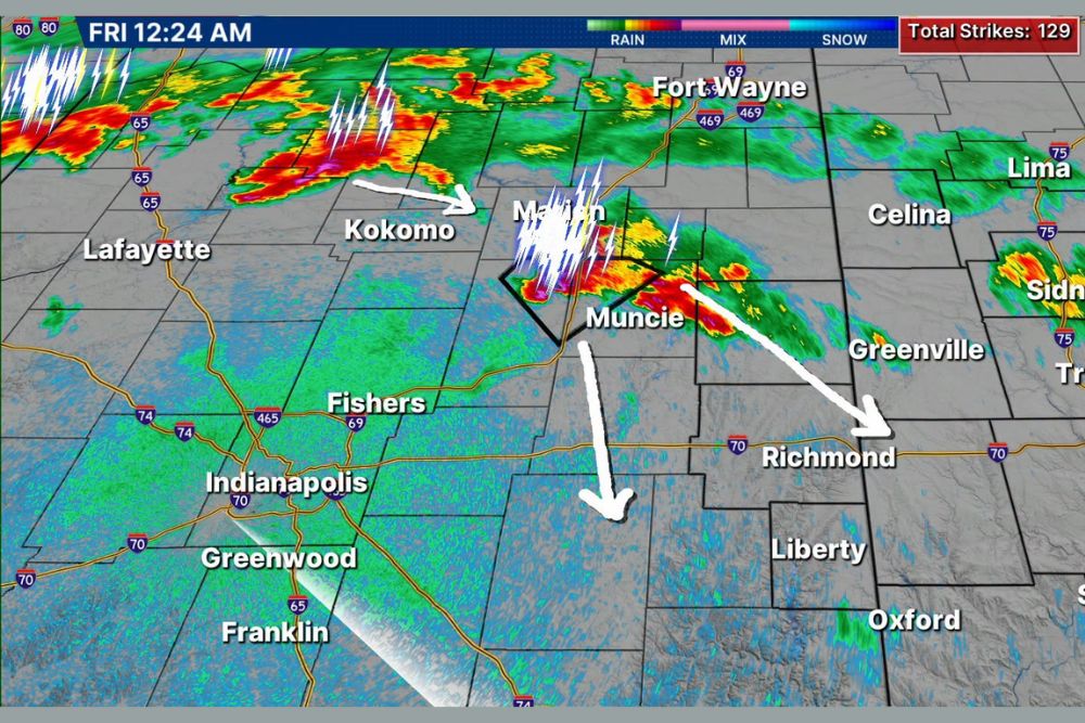
INDIANA — Intense thunderstorms with very heavy rain are approaching the region early Friday morning, with an estimated track drawn for two separate areas of interest currently being tracked. The cell near Muncie is severe as well, producing up to golf-ball size hail as it continues moving through east-central Indiana.
Muncie Storm Cell Producing Golf Ball Size Hail
Live radar captured at 12:24 a.m. Friday shows an intense storm cell positioned directly over Muncie, with a warning polygon actively outlined around the area and frequent lightning strikes visible within the cell. This storm has produced hail up to golf-ball size, marking it as the more immediately severe of the two tracked systems.
The Muncie cell’s estimated track carries it toward Richmond and areas farther southeast, with the storm’s intensity expected to continue posing a hail and heavy rain threat as it progresses along this path.
Second Area Near Kokomo and Marion Also Being Tracked
A second area of interest is tracked farther northwest near Kokomo and Marion, showing an estimated path curving southeast toward Indianapolis and the surrounding Fishers and Greenwood area. This system, while separate from the Muncie cell, is part of the broader intense thunderstorm activity moving through early Friday morning.
Both tracked areas reflect the intense nature of overnight thunderstorm activity, with a total of 129 lightning strikes recorded on the radar display, underscoring the electrical intensity accompanying the heavy rain across the region.
Flooding Could Quickly Ramp Up for Several Communities
Communities including Muncie, Winchester, Richmond, Cambridge City, New Castle, and Connersville are being given an early heads up that flooding could quickly ramp up as these intense thunderstorms with very heavy rain continue moving through the area overnight.
Given the potential for rapid flooding development, residents in these communities are urged to have reliable ways to receive weather warnings, particularly given the overnight timing when flash flooding can catch people off guard while sleeping.
Meteorologists Continue Tracking Storms Closely Overnight
Weather center staff are actively tracking this situation closely overnight and plan to provide additional cut-in coverage as necessary should conditions continue to intensify or new warnings become necessary for the tracked storm cells.
Residents throughout east-central Indiana, including Muncie, Richmond, and New Castle, should stay weather aware through the early morning hours as both tracked areas of storms continue moving through the region.
Leave a Reply