
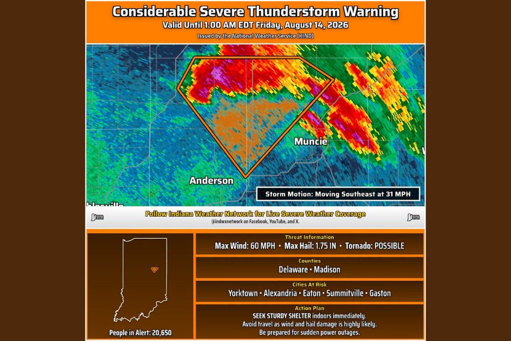
INDIANA — A Considerable Severe Thunderstorm Warning has been issued for Delaware and Madison Counties in Indiana until 1:00 a.m. EDT Friday, August 14. The warning carries a possible tornado threat, a considerable thunderstorm damage threat, wind gusts up to 60 mph, and hail up to 1.75 inches as the storm moves southeast at 31 mph.
Warning Polygon Covers Muncie and Anderson Directly
The warning polygon, issued by the National Weather Service office in Indianapolis, covers a corridor directly between Anderson and Muncie, with radar showing an intense core of purple and red returns positioned squarely within the warned area.
Storm motion places the system moving southeast at 31 mph, meaning the warned area will continue shifting as the storm tracks through Delaware and Madison Counties over the course of the warning period.
Considerable Damage Threat Reflects Elevated Storm Intensity
This warning carries a Considerable tag, a classification the National Weather Service reserves for storms posing an elevated threat of significant damage, distinct from the more common Base or Destructive designations. The considerable threat level reflects radar-indicated intensity consistent with damaging winds and large hail.
Maximum wind gusts are forecast at 60 mph, with hail growing as large as 1.75 inches in diameter possible within the strongest portion of the storm as it continues its southeastward track.
Yorktown, Alexandria, Eaton, and Additional Communities at Risk
Cities specifically identified as at risk from this warning include Yorktown, Alexandria, Eaton, Summitville, and Gaston. These communities fall within or near the path of the warned storm as it continues moving through Delaware and Madison Counties.
An estimated 20,650 people currently fall within the alert area for this warning, reflecting the population directly in the path of the storm’s considerable wind, hail, and tornado threat.
Residents Urged to Seek Sturdy Shelter Immediately
The recommended action plan calls for residents to seek sturdy shelter indoors immediately, avoid travel given the high likelihood of wind and hail damage, and be prepared for sudden power outages as the storm moves through the warned counties.
Residents throughout Delaware and Madison Counties, including Muncie, Anderson, and the surrounding at-risk communities, should take immediate shelter and monitor local alerts until the warning expires at 1:00 a.m.

Leave a Reply