Skip to content

Home

About Us

Contact Us

  • Facebook
  • X
  • Instagram
  • Pinterest
  • WhatsApp
  • RSS Feed
  • TikTok

Seven Lakes News

Your Trusted Voice Across the World.

Search

Golf Ball Size Hail Reported Near Muncie as Intense Storms With Flash Flood Potential Track Toward Winchester, Richmond, and New Castle Overnight

Justin Lyle Avatar
Justin Lyle
August 14, 2026
Golf Ball Size Hail Reported Near Muncie as Intense Storms With Flash Flood Potential Track Toward Winchester, Richmond, and New Castle Overnight

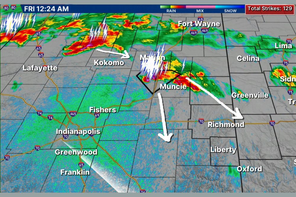
INDIANA — Intense thunderstorms with very heavy rain are approaching the region early Friday morning, with an estimated track drawn for two separate areas of interest currently being tracked. The cell near Muncie is severe as well, producing up to golf-ball size hail as it continues moving through east-central Indiana.

Muncie Storm Cell Producing Golf Ball Size Hail

Live radar captured at 12:24 a.m. Friday shows an intense storm cell positioned directly over Muncie, with a warning polygon actively outlined around the area and frequent lightning strikes visible within the cell. This storm has produced hail up to golf-ball size, marking it as the more immediately severe of the two tracked systems.

The Muncie cell’s estimated track carries it toward Richmond and areas farther southeast, with the storm’s intensity expected to continue posing a hail and heavy rain threat as it progresses along this path.

Second Area Near Kokomo and Marion Also Being Tracked

A second area of interest is tracked farther northwest near Kokomo and Marion, showing an estimated path curving southeast toward Indianapolis and the surrounding Fishers and Greenwood area. This system, while separate from the Muncie cell, is part of the broader intense thunderstorm activity moving through early Friday morning.

Both tracked areas reflect the intense nature of overnight thunderstorm activity, with a total of 129 lightning strikes recorded on the radar display, underscoring the electrical intensity accompanying the heavy rain across the region.

Flooding Could Quickly Ramp Up for Several Communities

Communities including Muncie, Winchester, Richmond, Cambridge City, New Castle, and Connersville are being given an early heads up that flooding could quickly ramp up as these intense thunderstorms with very heavy rain continue moving through the area overnight.

Given the potential for rapid flooding development, residents in these communities are urged to have reliable ways to receive weather warnings, particularly given the overnight timing when flash flooding can catch people off guard while sleeping.

Meteorologists Continue Tracking Storms Closely Overnight

Weather center staff are actively tracking this situation closely overnight and plan to provide additional cut-in coverage as necessary should conditions continue to intensify or new warnings become necessary for the tracked storm cells.

Residents throughout east-central Indiana, including Muncie, Richmond, and New Castle, should stay weather aware through the early morning hours as both tracked areas of storms continue moving through the region.
Leave a Reply Cancel reply

Your email address will not be published. Required fields are marked *

Featured Articles

  • Southern Illinois Braces for Hottest Day of the Year With St. Louis and Paducah Reaching One Hundred Degrees in Actual Air Temperature

    Southern Illinois Braces for Hottest Day of the Year With St. Louis and Paducah Reaching One Hundred Degrees in Actual Air Temperature

    August 15, 2026
  • Crazy Wind and Lightning Bring Down Big Branches Near Converse College as Spartanburg County Records Nearly Two Inches of Rain

    Crazy Wind and Lightning Bring Down Big Branches Near Converse College as Spartanburg County Records Nearly Two Inches of Rain

    August 15, 2026
  • Life Threatening Flooding Threatens Hawaii as Tropical Storm Lala Nears Hurricane Strength With Isolated Rainfall Totals Reaching Twenty Five Inches

    Life Threatening Flooding Threatens Hawaii as Tropical Storm Lala Nears Hurricane Strength With Isolated Rainfall Totals Reaching Twenty Five Inches

    August 15, 2026
  • Another Overnight Storm Round Begins Early Near Fort Madison and Macomb With Rapid Development Expected Across Illinois and Iowa

    Another Overnight Storm Round Begins Early Near Fort Madison and Macomb With Rapid Development Expected Across Illinois and Iowa

    August 15, 2026
  • Severe Storms Fire Again Saturday From Fort Wayne to Charlotte as Mesoscale Convective Vortex Travels Toward Appalachians With High Wind Risk

    Severe Storms Fire Again Saturday From Fort Wayne to Charlotte as Mesoscale Convective Vortex Travels Toward Appalachians With High Wind Risk

    August 15, 2026

Search

Follow Us on

  • Facebook
  • X
  • Instagram
  • VK
  • Pinterest
  • Last.fm
  • TikTok
  • Telegram
  • WhatsApp
  • RSS Feed

Categories

  • Climate Forecast (39)

About Seven Lakes News

We cover the weather that changes your day: storm warnings, heat and cold advisories, flooding, snow, and the forecasts behind them. We are not the National Weather Service and we do not issue warnings. When severe weather is close, check weather.gov or your local NWS office before you act on anything you read here.

Latest Articles

  • Southern Illinois Braces for Hottest Day of the Year With St. Louis and Paducah Reaching One Hundred Degrees in Actual Air Temperature

    Southern Illinois Braces for Hottest Day of the Year With St. Louis and Paducah Reaching One Hundred Degrees in Actual Air Temperature

    August 15, 2026
  • Crazy Wind and Lightning Bring Down Big Branches Near Converse College as Spartanburg County Records Nearly Two Inches of Rain

    Crazy Wind and Lightning Bring Down Big Branches Near Converse College as Spartanburg County Records Nearly Two Inches of Rain

    August 15, 2026
  • Life Threatening Flooding Threatens Hawaii as Tropical Storm Lala Nears Hurricane Strength With Isolated Rainfall Totals Reaching Twenty Five Inches

    Life Threatening Flooding Threatens Hawaii as Tropical Storm Lala Nears Hurricane Strength With Isolated Rainfall Totals Reaching Twenty Five Inches

    August 15, 2026

Categories

  • Climate Forecast (39)
August 2026
M T W T F S S
 12
3456789
10111213141516
17181920212223
24252627282930
31  
     

© 2026 Seven Lakes News | All Rights Reserved.

Scroll to Top