
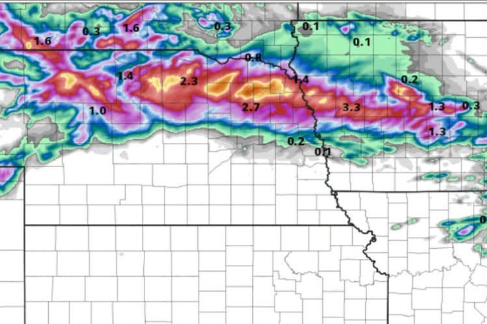
NEBRASKA — The HiRes model is showing heavy rain developing Wednesday night across northeast Nebraska, with yellow shading and above supporting 4 inches or more of rainfall by 7 a.m. Thursday. In-house forecasting techniques yield a maximum report potential in this area of 7.0 to 7.5 inches, with flash flooding likely if the model forecast proves correct.
Heaviest Rainfall Band Targets Northeast Nebraska Corridor
Model guidance shows a concentrated band of heavy rainfall stretching across northeast Nebraska, with the highest projected totals of 2.3 to 3.3 inches shown in the core of the system. This band extends from the western part of the forecast area eastward toward the Nebraska and Iowa border region.
The most intense rainfall totals are concentrated in a corridor running roughly parallel to the northern tier of Nebraska, with values progressively decreasing to the north and south of this central axis of heaviest precipitation.
In-House Techniques Suggest Isolated Totals Could Reach Seven Inches
Beyond the base model output, in-house forecasting techniques applied to this event yield a maximum report potential of 7.0 to 7.5 inches within the heaviest-hit corridor. This significantly exceeds the raw model numbers and reflects additional analysis of how the heaviest cells could train over the same locations.
Should these higher totals verify, the resulting rainfall would fall well into flash flood territory for a single overnight event, particularly given the compressed timeframe between Wednesday night and Thursday morning.
Flash Flooding Likely if Forecast Verifies as Modeled
Forecasters indicate flash flooding is likely across the affected area if the model forecast proves correct, given the combination of high rainfall rates and significant total accumulation projected within a roughly 12-hour overnight window.
The risk for flash flooding would be greatest in areas that fall within the highest-end totals near the 4-inch-plus shaded zone, where rapid runoff could quickly overwhelm drainage systems and low-lying areas across northeast Nebraska.
Wednesday Night Into Thursday Morning Marks Highest Risk Window
The primary window of concern spans Wednesday night through 7 a.m. Thursday, based on the model initialization and rainfall totals presented. This overnight timing adds to the potential danger, since flash flooding can develop and worsen while many residents are asleep.
Residents across northeast Nebraska are encouraged to stay weather aware Wednesday night into early Thursday morning and avoid driving through flooded roadways if heavy rain and flash flooding develop as the model guidance suggests.
Leave a Reply