Skip to content

Home

About Us

Contact Us

  • Facebook
  • X
  • Instagram
  • Pinterest
  • WhatsApp
  • RSS Feed
  • TikTok

Seven Lakes News

Your Trusted Voice Across the World.

Search

Another Bow Echo Sends Strong Thunderstorm Winds Through Chicago Suburbs With Gusts to Seventy-Five MPH Reported Near Midway Airport

Justin Lyle Avatar
Justin Lyle
August 12, 2026
Another Bow Echo Sends Strong Thunderstorm Winds Through Chicago Suburbs With Gusts to Seventy-Five MPH Reported Near Midway Airport

ILLINOIS — More strong thunderstorm winds are impacting the Chicago area this morning as another bow echo moves through the region. Thankfully this system gusted out before reaching the city itself, so most gusts are generally below 60 mph, though it is still enough to cause a headache for an area already tired of severe weather this season.

Wind Gusts Reach Seventy-Five MPH Near Midway Airport

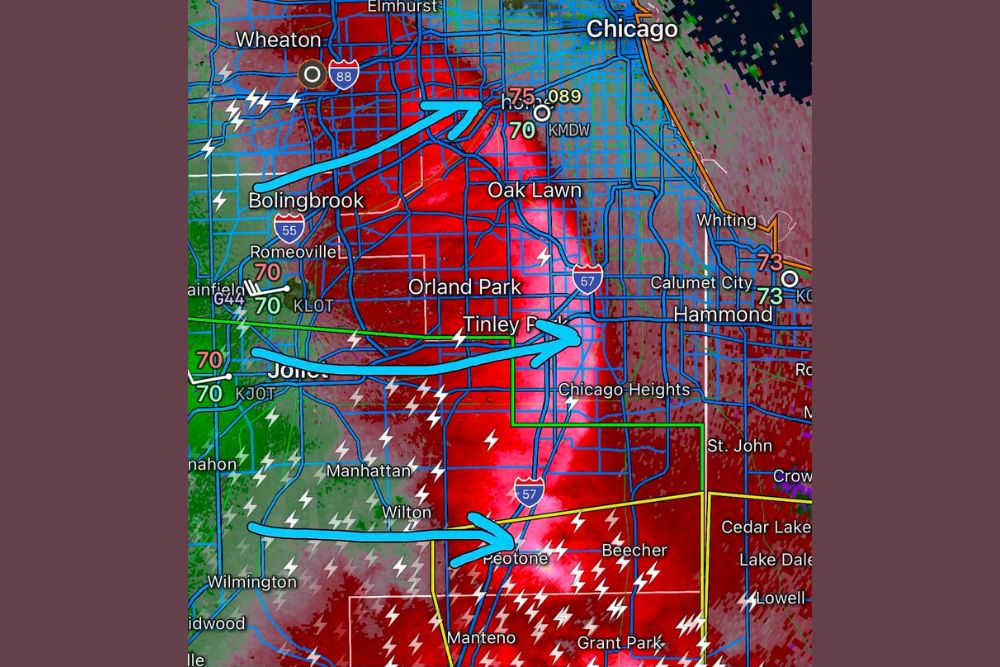
Storm reports show a peak gust of 75 mph recorded near Midway Airport, with an additional 70 mph gust also noted in the immediate area. These readings represent the strongest winds associated with this morning’s bow echo as it tracked through the southern Chicago suburbs.

Communities including Oak Lawn and the area surrounding Midway saw the most intense impacts from this round, with radar showing an extensive area of heavy rain and embedded lightning accompanying the strongest wind gusts.

Bow Echo Weakens Before Reaching City Limits

Forecasters noted the bow echo gusted out before reaching the city of Chicago itself, meaning most locations experienced gusts generally below 60 mph rather than the more extreme readings recorded farther south and west. This weakening trend limited the potential for more widespread significant damage closer to downtown.

Communities including Bolingbrook, Romeoville, and Joliet reported gusts around 70 mph as the system moved through, with radar showing the bow echo structure clearly visible as it tracked northeast across the metro area.

System Tracks Southeast Toward Indiana State Line

The bow echo continued tracking southeast through communities including Tinley Park, Chicago Heights, and Peotone, maintaining an organized structure as it approached the Indiana state line near Hammond, St. John, and Cedar Lake.

Wind gusts of 73 mph were reported near the state line in the Whiting and Hammond area, indicating the system retained significant strength even as it moved beyond the immediate Chicago suburbs and into northwestern Indiana.

Chicago Area Continues Facing Fatigue From Repeated Severe Rounds

This latest round adds to what has been a persistently active stretch of severe weather for the Chicago area, with residents and forecasters alike growing weary of the repeated impacts. While this particular event avoided the most severe outcomes for the city core, the suburban impacts remain notable.

Residents throughout the southern Chicago suburbs and into northwestern Indiana are encouraged to continue monitoring conditions as additional rounds of storms remain possible with the area’s ongoing active weather pattern.
Leave a Reply Cancel reply

Your email address will not be published. Required fields are marked *

Featured Articles

  • Invest 92L Spaghetti Models Show General Westward Track Through Caribbean With Strong Wind Shear Threatening System While Trailing Wave Looks Healthy

    Invest 92L Spaghetti Models Show General Westward Track Through Caribbean With Strong Wind Shear Threatening System While Trailing Wave Looks Healthy

    August 12, 2026
  • Perseid Meteor Shower Peaks Tonight Across North Carolina With New Moon Skies but Passing Clouds Threatening Viewing Conditions Statewide

    Perseid Meteor Shower Peaks Tonight Across North Carolina With New Moon Skies but Passing Clouds Threatening Viewing Conditions Statewide

    August 12, 2026
  • Severe Storm Complex Barrels Across Northern Illinois Toward South Bend With Damaging Winds Up to Seventy-Five MPH and Spin Up Tornado Risk

    Severe Storm Complex Barrels Across Northern Illinois Toward South Bend With Damaging Winds Up to Seventy-Five MPH and Spin Up Tornado Risk

    August 12, 2026
  • HiRes Model Points to Four Inch Plus Rain Totals Over Northeast Nebraska Wednesday Night With Isolated Amounts Reaching Up to Seven and a Half Inches

    HiRes Model Points to Four Inch Plus Rain Totals Over Northeast Nebraska Wednesday Night With Isolated Amounts Reaching Up to Seven and a Half Inches

    August 12, 2026
  • Another Bow Echo Sends Strong Thunderstorm Winds Through Chicago Suburbs With Gusts to Seventy-Five MPH Reported Near Midway Airport

    Another Bow Echo Sends Strong Thunderstorm Winds Through Chicago Suburbs With Gusts to Seventy-Five MPH Reported Near Midway Airport

    August 12, 2026

Search

Follow Us on

  • Facebook
  • X
  • Instagram
  • VK
  • Pinterest
  • Last.fm
  • TikTok
  • Telegram
  • WhatsApp
  • RSS Feed

Categories

  • Climate Forecast (16)

About Seven Lakes News

We cover the weather that changes your day: storm warnings, heat and cold advisories, flooding, snow, and the forecasts behind them. We are not the National Weather Service and we do not issue warnings. When severe weather is close, check weather.gov or your local NWS office before you act on anything you read here.

Latest Articles

  • Invest 92L Spaghetti Models Show General Westward Track Through Caribbean With Strong Wind Shear Threatening System While Trailing Wave Looks Healthy

    Invest 92L Spaghetti Models Show General Westward Track Through Caribbean With Strong Wind Shear Threatening System While Trailing Wave Looks Healthy

    August 12, 2026
  • Perseid Meteor Shower Peaks Tonight Across North Carolina With New Moon Skies but Passing Clouds Threatening Viewing Conditions Statewide

    Perseid Meteor Shower Peaks Tonight Across North Carolina With New Moon Skies but Passing Clouds Threatening Viewing Conditions Statewide

    August 12, 2026
  • Severe Storm Complex Barrels Across Northern Illinois Toward South Bend With Damaging Winds Up to Seventy-Five MPH and Spin Up Tornado Risk

    Severe Storm Complex Barrels Across Northern Illinois Toward South Bend With Damaging Winds Up to Seventy-Five MPH and Spin Up Tornado Risk

    August 12, 2026

Categories

  • Climate Forecast (16)
August 2026
M T W T F S S
 12
3456789
10111213141516
17181920212223
24252627282930
31  
     

© 2026 Seven Lakes News | All Rights Reserved.

Scroll to Top