
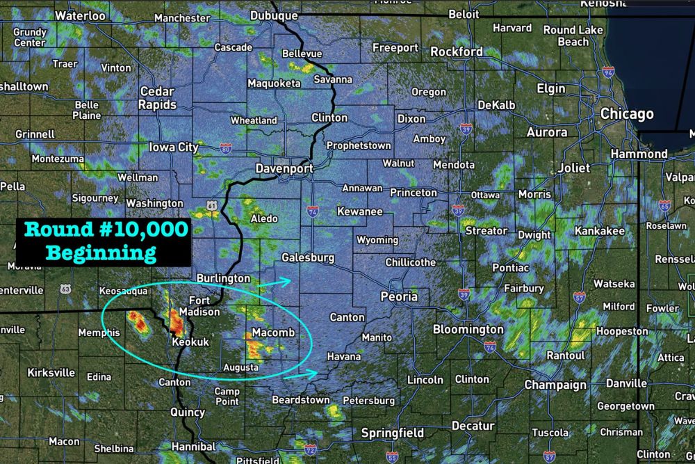
ILLINOIS — Another overnight round of storms is beginning a smidge early Thursday night, developing initially near Fort Madison, Keokuk, and Macomb along the Iowa and Illinois border. Storms will blow up fast, meaning the currently mostly empty radar image should not be taken as a sign of a quiet night ahead across the region.
Initial Storm Development Centered Near Fort Madison and Keokuk
Radar shows the earliest cells of this overnight round developing near Fort Madison and Keokuk along the Mississippi River, with additional activity building near Macomb, Illinois. These initial cells mark the starting point for what forecasters expect to become a more widespread round of storms overnight.
An estimated track shows this developing activity continuing to expand and move northeast from its current position near the Iowa and Illinois border, consistent with the broader pattern of storms that has repeatedly tracked across this same general corridor throughout the week.
Storms Expected to Rapidly Intensify Despite Quiet Current Radar
Forecasters specifically cautioned that storms will blow up fast, so residents should not let the mostly empty radar image across much of the broader region trick them into thinking conditions will remain calm. The current lull in coverage is expected to be temporary as the overnight round continues developing.
This rapid intensification pattern has become a recurring theme in recent rounds of storms, where seemingly quiet radar can transition quickly into more significant coverage as instability and available moisture fuel fast development after dark.
Broader Region From Cedar Rapids to Chicago Remains in Play
While the initial development is centered near Fort Madison and Macomb, the broader region stretching from Cedar Rapids and Davenport through Peoria, Bloomington, and toward Chicago and Joliet remains within the area that could see storms as the overnight round continues to organize and expand.
Communities across this wide swath of Iowa and Illinois should remain prepared for the possibility of storms developing overhead even in areas where radar currently shows little to no activity.
Residents Urged to Stay Alert as Overnight Round Develops
Given the fast development expected with this round, residents across the affected region are encouraged to have a reliable way to receive weather alerts overnight, since conditions could change quickly from the currently quiet radar picture to active storm coverage.
Residents throughout eastern Iowa and western and central Illinois, including Fort Madison, Macomb, and Peoria, should stay weather aware overnight as this latest round in an active week of storms continues to develop and expand.
Leave a Reply