Skip to content

Home

About Us

Contact Us

  • Facebook
  • X
  • Instagram
  • Pinterest
  • WhatsApp
  • RSS Feed
  • TikTok

Seven Lakes News

Your Trusted Voice Across the World.

Search

Monsoon Pattern Shuts Off Across Ohio Starting August Eighteenth With Well Below Normal Rainfall Expected Through the First Week of September

Justin Lyle Avatar
Justin Lyle
August 15, 2026
Monsoon Pattern Shuts Off Across Ohio Starting August Eighteenth With Well Below Normal Rainfall Expected Through the First Week of September

OHIO — The active monsoon-style pattern that has brought repeated rounds of storms is about to slam the brakes and flip into a dry, quiet stretch across Ohio. Starting August 18 to 19 and lasting straight through the first week of September, models show a strong shift toward very limited rainfall, well below normal precipitation, and no major severe weather signals for an extended two to three week period.

Statewide Shift Toward Well Below Normal Rainfall Expected

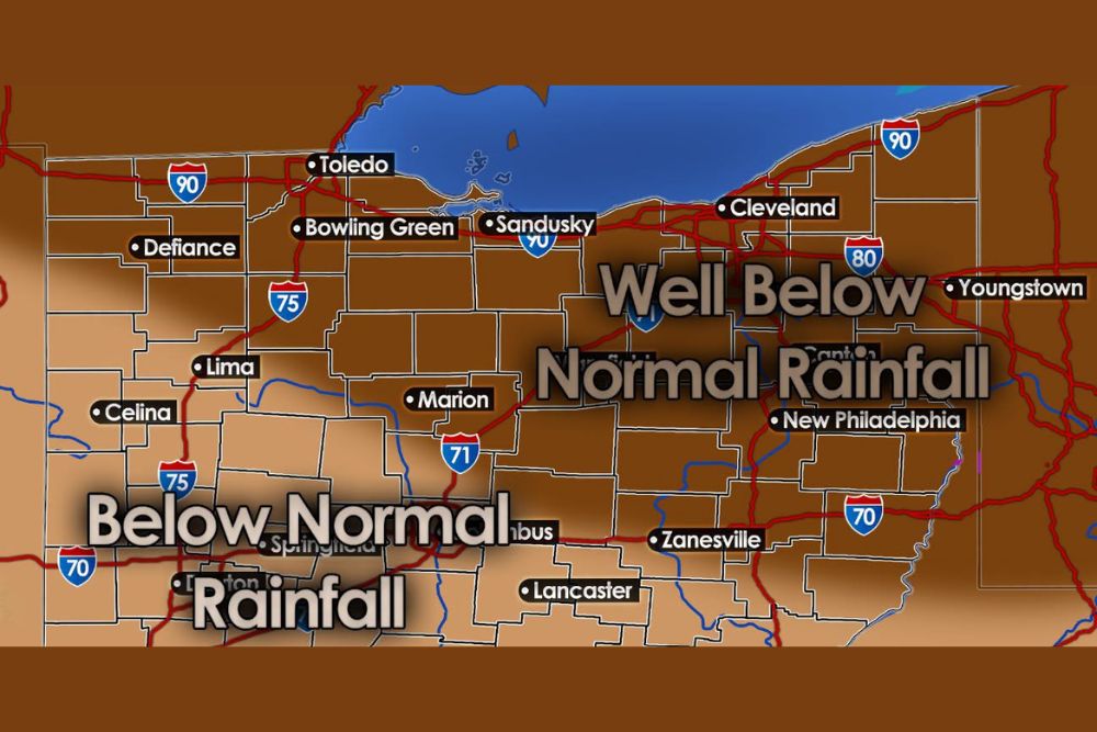
Model guidance points to well below normal rainfall across northern and eastern Ohio, including communities such as Toledo, Cleveland, Youngstown, and New Philadelphia. This designation reflects the most significant precipitation deficit expected across the state during the upcoming dry stretch.

A slightly less extreme but still notably dry category of below normal rainfall covers much of western and southern Ohio, including Lima, Marion, Columbus, and Zanesville, indicating the entire state will trend drier regardless of specific location.

No Major Rainmakers or Severe Weather Signals in Extended Outlook

Models show no big rainmakers and no major severe weather signals within the extended outlook covering roughly two to three weeks. While a random shower here or there remains possible, nothing organized or widespread is expected to develop during this stretch.

Even this weekend’s severe weather potential is already backing off slightly in the latest model runs, suggesting the transition toward calmer conditions may begin taking hold even before the more firmly established dry pattern arrives August 18 to 19.

Late August Into Early September Brings Below Normal Temperatures

Beyond the dry pattern, late August and early September are also expected to feature below normal temperatures alongside the below normal rainfall. Dewpoints are forecast to run in the 40s and 50s, reflecting notably comfortable and low-humidity conditions for the time of year.

This combination of cooler temperatures and low dewpoints would create an atmosphere reminiscent of early fall weather, a significant departure from the typically warm and humid conditions Ohio experiences during late summer.

Residents Encouraged to Get Through This Weekend Before Calm Arrives

Forecasters emphasize that residents just need to get through this weekend before smooth, quiet sailing arrives for an extended period. This represents a notable shift in pattern following what has been an active stretch of monsoon-style weather across the state.

Residents throughout Ohio can look forward to an extended period of dry, mild conditions once the transition takes hold, offering a welcome change of pace after the recent stretch of active and often impactful weather.
Leave a Reply Cancel reply

Your email address will not be published. Required fields are marked *

Featured Articles

  • Southern Illinois Braces for Hottest Day of the Year With St. Louis and Paducah Reaching One Hundred Degrees in Actual Air Temperature

    Southern Illinois Braces for Hottest Day of the Year With St. Louis and Paducah Reaching One Hundred Degrees in Actual Air Temperature

    August 15, 2026
  • Crazy Wind and Lightning Bring Down Big Branches Near Converse College as Spartanburg County Records Nearly Two Inches of Rain

    Crazy Wind and Lightning Bring Down Big Branches Near Converse College as Spartanburg County Records Nearly Two Inches of Rain

    August 15, 2026
  • Life Threatening Flooding Threatens Hawaii as Tropical Storm Lala Nears Hurricane Strength With Isolated Rainfall Totals Reaching Twenty Five Inches

    Life Threatening Flooding Threatens Hawaii as Tropical Storm Lala Nears Hurricane Strength With Isolated Rainfall Totals Reaching Twenty Five Inches

    August 15, 2026
  • Another Overnight Storm Round Begins Early Near Fort Madison and Macomb With Rapid Development Expected Across Illinois and Iowa

    Another Overnight Storm Round Begins Early Near Fort Madison and Macomb With Rapid Development Expected Across Illinois and Iowa

    August 15, 2026
  • Severe Storms Fire Again Saturday From Fort Wayne to Charlotte as Mesoscale Convective Vortex Travels Toward Appalachians With High Wind Risk

    Severe Storms Fire Again Saturday From Fort Wayne to Charlotte as Mesoscale Convective Vortex Travels Toward Appalachians With High Wind Risk

    August 15, 2026

Search

Follow Us on

  • Facebook
  • X
  • Instagram
  • VK
  • Pinterest
  • Last.fm
  • TikTok
  • Telegram
  • WhatsApp
  • RSS Feed

Categories

  • Climate Forecast (39)

About Seven Lakes News

We cover the weather that changes your day: storm warnings, heat and cold advisories, flooding, snow, and the forecasts behind them. We are not the National Weather Service and we do not issue warnings. When severe weather is close, check weather.gov or your local NWS office before you act on anything you read here.

Latest Articles

  • Southern Illinois Braces for Hottest Day of the Year With St. Louis and Paducah Reaching One Hundred Degrees in Actual Air Temperature

    Southern Illinois Braces for Hottest Day of the Year With St. Louis and Paducah Reaching One Hundred Degrees in Actual Air Temperature

    August 15, 2026
  • Crazy Wind and Lightning Bring Down Big Branches Near Converse College as Spartanburg County Records Nearly Two Inches of Rain

    Crazy Wind and Lightning Bring Down Big Branches Near Converse College as Spartanburg County Records Nearly Two Inches of Rain

    August 15, 2026
  • Life Threatening Flooding Threatens Hawaii as Tropical Storm Lala Nears Hurricane Strength With Isolated Rainfall Totals Reaching Twenty Five Inches

    Life Threatening Flooding Threatens Hawaii as Tropical Storm Lala Nears Hurricane Strength With Isolated Rainfall Totals Reaching Twenty Five Inches

    August 15, 2026

Categories

  • Climate Forecast (39)
August 2026
M T W T F S S
 12
3456789
10111213141516
17181920212223
24252627282930
31  
     

© 2026 Seven Lakes News | All Rights Reserved.

Scroll to Top