
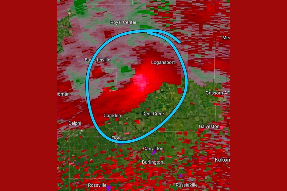
INDIANA — Meteorologists are expressing deep concern over an area of rotation currently tracking near Logansport, with an urgent message that anyone east southeast or southeast of this location needs to be taking shelter immediately. The circled area on radar shows a strong velocity signature consistent with a storm capable of producing a tornado.
Circled Rotation Signature Centers Directly Over Logansport
Radar velocity data shows a pronounced circulation signature centered directly over Logansport, with the highlighted area extending from near Royal Center and Burnettsville through Camden, Deer Creek, and Flora. This circled zone represents the area of greatest concern for rotation associated with the storm.
The intensity of the radar returns within and surrounding the circled area, showing deep red and embedded pink and purple cores, reflects a storm capable of producing significant hazards for communities in its direct path.
Communities Southeast of Rotation Urged to Take Shelter Now
Given the storm’s current position and typical eastward or northeastward storm motion, meteorologists specifically warned that those east southeast or southeast of the circled rotation area need to be taking shelter immediately. This includes communities such as Deer Creek, Galveston, and areas approaching Grissom Air Force Base.
This urgent framing reflects genuine concern about the storm’s potential to continue producing a tornado threat as it tracks toward these downstream communities in the coming minutes.
Broader Storm Complex Extends Across Multiple Counties
Beyond the immediate circled rotation area, the broader radar image shows extensive storm coverage stretching from Winamac and Rochester in the north through Kokomo, Russiaville, and Rossville to the south. This widespread red shading indicates a large and active storm complex beyond just the rotating cell.
Communities throughout this broader area, including Delphi, Carrollton, and Burlington, remain within the path of significant thunderstorm activity even outside the specific zone of greatest rotational concern.
Residents Urged to Monitor Situation Closely as Storm Continues
Given the urgency conveyed regarding the rotation near Logansport, residents throughout north-central Indiana are strongly encouraged to have a reliable way to receive warnings and to act immediately if official tornado warnings are issued for their specific location.
Residents across the affected region, including Logansport, Camden, and Deer Creek, should continue monitoring official National Weather Service updates as this potentially dangerous storm continues its track through the area.
Leave a Reply