
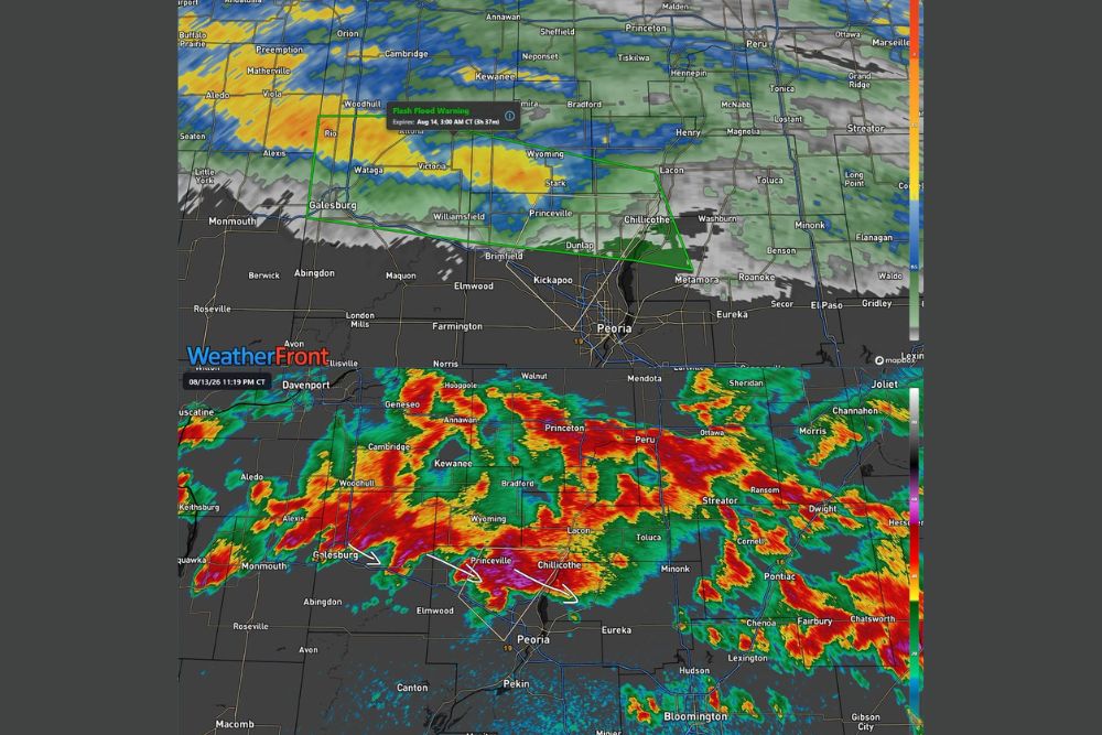
ILLINOIS — The first Flash Flood Warning of the evening has been issued for Knox, Marshall, Peoria, Stark, and Woodford Counties until 3 a.m. Storms have already dropped 1 to 2 inches of rain, with another 1 to 2 inches expected in the next few hours, meaning flash flooding is expected to begin shortly if it has not already.
Warning Polygon Covers Corridor From Galesburg to Chillicothe
The Flash Flood Warning, active until 3 a.m. Thursday, covers a corridor stretching from near Galesburg and Wataga through Williamsfield and Princeville before reaching Chillicothe near Peoria. Radar shows a broad area of green and yellow returns blanketing this warned zone.
Communities including Stark and Dunlap fall within the warning polygon, where the combination of already-fallen rain and additional expected rainfall creates the elevated flash flooding concern through the overnight hours.
Additional One to Two Inches Expected Within Hours
Beyond the 1 to 2 inches of rain that has already fallen across the warned counties, another 1 to 2 inches is expected within the next few hours. This additional rainfall on top of already-saturated ground significantly raises the likelihood of rapid flash flooding development.
The combination of these two rounds of rainfall, totaling potentially 2 to 4 inches when combined, represents a significant overnight rainfall event capable of quickly overwhelming drainage systems across the warned area.
Training Supercells Watched Along and North of Interstate 74
Beyond the flash flood warning, training supercells are also being watched along and north of Interstate 74, an area that includes communities near Peoria and extending east toward Pontiac and Chatsworth based on the radar’s intense red and purple cores.
In addition to heavy rain, these training supercells may produce wind gusts up to 50 mph, adding a damaging wind component to the ongoing heavy rainfall and flash flooding threat already affecting the region.
Storms Continue Tracking Southeast Across Central Illinois
Radar valid at 11:19 p.m. shows the broader storm complex continuing to track southeast, with estimated movement carrying activity from Galesburg through Princeville and Chillicothe. The most intense cores, shown in red and purple, are concentrated near Peoria and extending toward Pontiac.
Residents across Knox, Marshall, Peoria, Stark, and Woodford Counties are urged to stay weather aware overnight and avoid flooded roadways as flash flooding develops, with additional communities near Interstate 74 also watching for potential damaging wind gusts.
Leave a Reply